

 View from National Road 150") Paganzo | Shrubland with cacti
Paganzo | Shrubland with cacti View from National Road 150") Patquía | Shrubland with cacti
Patquía | Shrubland with cacti View in SW direction") Patquía | Ruta Nacional 150
Patquía | Ruta Nacional 150 Aspidosperma quebracho-blanco") La Rioja | White quebracho
La Rioja | White quebracho Stetsonia coryne") La Rioja | Toothpick cactus with flower
La Rioja | Toothpick cactus with flower Stetsonia coryne") La Rioja | Toothpick cactus
La Rioja | Toothpick cactus This tree can store water in its stem in order to cope with dry periods.") Catamarca | Succulent tree
Catamarca | Succulent tree This genus of epiphytic bromeliads is common in areas of South America with humid air. It does not o...") Tucumán | Fence with tillandsia
Tucumán | Fence with tillandsia The yungas are a certain type of mountain rain and cloud forests. They can be found in those areas w...") Quebrada de Los Sosa | Yungas
Quebrada de Los Sosa | Yungas The yungas are a certain type of mountain rain and cloud forests. They can be found in those areas w...") Quebrada de Los Sosa | Yungas
Quebrada de Los Sosa | Yungas The yungas are a certain type of mountain rain and cloud forests. They can be found in those areas w...") Quebrada de Los Sosa | Yungas
Quebrada de Los Sosa | Yungas The yungas are a certain type of mountain rain and cloud forests. They can be found in those areas w...") Quebrada de Los Sosa | Yungas
Quebrada de Los Sosa | Yungas The yungas are a certain type of mountain rain and cloud forests. They can be found in those areas w...") Quebrada de Los Sosa | Yungas
Quebrada de Los Sosa | Yungas Patches of the yungas forest occupying damp ravines near the treeline at approx. 2100-2200 m asl. Mo...") Tafí del Valle | Treeline area
Tafí del Valle | Treeline area View from the Provincial Road 307 in S direction down to the Valle de Tafí with Tafí del Valle and...") Valle de Tafí with Lago El Mollar
Valle de Tafí with Lago El Mollar View from the Provincial Road 307 in S direction down to the Valle de Tafí with Tafí del Valle and...") Valle de Tafí with Lago El Mollar
Valle de Tafí with Lago El Mollar View from the Provincial Road 307 in S direction down to the Valle de Tafí with Tafí del Valle and...") Valle de Tafí with Lago El Mollar
Valle de Tafí with Lago El Mollar View from the Provincial Road 307 in NW direction") Sierra de Aconquija with mountain pastures
Sierra de Aconquija with mountain pastures View from the Provincial Road 307 in SW direction to the Sierra de Aconquija. Llamas are kept as liv...") Abra del Infernillo | Alpine grassland with llamas
Abra del Infernillo | Alpine grassland with llamas Llamas are kept as livestock in this area at approx. 3000 m asl.") Abra del Infernillo | Llamas
Abra del Infernillo | Llamas Chilean bus driver taking a well-deserved rest at the top of Abra del Infernillo (3070 m)") Abra del Infernillo
Abra del Infernillo These cacti most likely belong to the species Echinopsis terscheckii (cardón grande).") Amaicha del Valle | Los Cardones
Amaicha del Valle | Los Cardones This cactus most likely belongs to the species Echinopsis terscheckii (cardón grande).") Amaicha del Valle | Los Cardones
Amaicha del Valle | Los Cardones These cacti most likely belong to the species Echinopsis terscheckii (cardón grande).") Amaicha del Valle | Los Cardones
Amaicha del Valle | Los Cardones This extraordinarily large and old individual of Echinopsis terscheckii (cardón grande) can be foun...") Amaicha del Valle | Los Cardones
Amaicha del Valle | Los Cardones View from the Finca Las Nubes across the Valles Calchaquíes in NE direction") Cafayate | Foehn clouds
Cafayate | Foehn clouds Plant of Senna aphylla near National Road 68") Quebrada de Las Conchas | Pichanilla
Quebrada de Las Conchas | Pichanilla View in S direction (upstream) along the Quebrada de Las Conchas, deeply incised into a sequence of ...") Quebrada de Las Conchas
Quebrada de Las Conchas View in N direction (downstream). The Quebrada de Las Conchas connects the tectonic grabens of the V...") Quebrada de Las Conchas
Quebrada de Las Conchas View from Alemanía in SW direction (upstream) to the lowermost section of the Quebrada de Las Conch...") Alemanía | Río de Las Conchas
Alemanía | Río de Las Conchas This village received its name due to the German workers constructing the railway from Salta through...") Valle de Lerma | Alemanía
Valle de Lerma | Alemanía Abandoned rail bridge, crossing the Río Alemanía and leading to the station of Alemanía. This pla...") Alemanía | Brücke der Guten Hoffnung
Alemanía | Brücke der Guten Hoffnung The Valle de Lerma is an important agricultural area. Unfortunately, rather unhealthy products are c...") Valle de Lerma | Tobacco cultivation
Valle de Lerma | Tobacco cultivation View from Cerro San Bernardo over the city of Salta, the main urban centre of the Valle de Lerma, in...") Valle de Lerma with Salta
Valle de Lerma with Salta View from a bridge near Villa Jardín de Reyes down the bed of Río Reyes in NE direction") Villa Jardín de Reyes | Río Reyes
Villa Jardín de Reyes | Río Reyes View from a bridge near Villa Jardín de Reyes up the braided bed of the Río Reyes in SW direction....") Villa Jardín de Reyes | Río Reyes and Cerro Cortaderal
Villa Jardín de Reyes | Río Reyes and Cerro Cortaderal View from a bridge near Villa Jardín de Reyes up the braided bed of the Río Reyes in SW direction....") Villa Jardín de Reyes | Río Reyes and Cerro Cortaderal
Villa Jardín de Reyes | Río Reyes and Cerro Cortaderal View from National Road 9") Quebrada de Humahuaca | Linear erosion
Quebrada de Humahuaca | Linear erosion View from National Road 52 upstream") Quebradilla de Purmamarca
Quebradilla de Purmamarca Location: Lan Tau Island, view from the track leading up to the summit of Lan Tau Peak") Hong Kong | Tian Tan Temple with Sitting Buddha
Hong Kong | Tian Tan Temple with Sitting Buddha Location: Lan Tau Island, view from Tian Tan Temple, summit elevation: 934 m") Hong Kong | Lan Tau Peak
Hong Kong | Lan Tau Peak Viewpoint near Ngong Ping, cable to Tung Chung New Town in the foreground") Hong Kong | Lan Tau Island with landslides
Hong Kong | Lan Tau Island with landslides View from the cable car Ngong Ping - Tung Chung New Town") Hong Kong | Lan Tau Island with landslides
Hong Kong | Lan Tau Island with landslides View from the cable car to Ngong Ping") Hong Kong | Tung Chung New Town
Hong Kong | Tung Chung New Town") Río Magdalena Valley | Cotton harvest
Río Magdalena Valley | Cotton harvest Fruit of the cotton plant Gossypium hirsutum") Río Magdalena Valley | Cotton
Río Magdalena Valley | Cotton") Río Magdalena Valley | Rice field
Río Magdalena Valley | Rice field") Tatacoa Desert | Badlands
Tatacoa Desert | Badlands") Tatacoa Desert | Badlands
Tatacoa Desert | Badlands") Tatacoa Desert | Badlands
Tatacoa Desert | Badlands") Tatacoa Desert | Columnar cacti
Tatacoa Desert | Columnar cacti View from the road Girardot-Neiva towards the Tatacoa desert and the Eastern Cordillera, grazing Zeb...") Río Magdalena Valley | Dry savanna
Río Magdalena Valley | Dry savanna View from the road Hobo-Gigante") Upper Río Magdalena valley
Upper Río Magdalena valley") Chinchiná | Guayabal coffee farm
Chinchiná | Guayabal coffee farm") Chinchiná | Guayabal coffee farm
Chinchiná | Guayabal coffee farm") Cartago | Cultural landscape
Cartago | Cultural landscape Carica papaya") Cauca valley | Papaya cultivation
Cauca valley | Papaya cultivation") Cauca Valley | Sugar cane cultivation
Cauca Valley | Sugar cane cultivation") Cauca Valley | Umbrella trees
Cauca Valley | Umbrella trees This important suspension bridge crossing the Río Cauca few kilometres S of Santa Fe was closed for...") Santa Fe de Antioquia | Puente Paso Real
Santa Fe de Antioquia | Puente Paso Real Panoramic view in NW direction, downstream the Río Cauca. At the time of completion in 1895, this h...") Santa Fe de Antioquia | Puente de Occidente
Santa Fe de Antioquia | Puente de Occidente At the time of completion in 1895, this hybrid suspension/cable-stayed bridge had the longest span i...") Santa Fe de Antioquia | Puente de Occidente
Santa Fe de Antioquia | Puente de Occidente Landslide and debris flow processes affecting the road connecting Liborina and Sabanalarga") La Honda | Landslide and debris flow
La Honda | Landslide and debris flow Debris flow processes affecting the road connecting Liborina and Sabanalarga") La Honda | Debris flow
La Honda | Debris flow View from El Junco across the Río Cauca in W direction. Rain shade effects result in a mosaic of sa...") Cauca Valley | Vegetation mosaic
Cauca Valley | Vegetation mosaic View from El Junco across the Río Cauca in W direction to the Cordillera Occidental. Rain shade eff...") Cauca Valley with El Guasimo Landslide
Cauca Valley with El Guasimo Landslide This reservoir, impounded by a 225 m high embankment dam on the Cauca River, belongs tho the Hidroit...") Cauca Valley | Hidroituango Reservoir
Cauca Valley | Hidroituango Reservoir This reservoir, impounded by a 225 m high embankment dam on the Cauca River, belongs tho the Hidroit...") Cauca Valley | Hidroituango Reservoir
Cauca Valley | Hidroituango Reservoir Flight Lisboa - Praia, view over Praia Baixo (bottom of the photo) in NW direction to the mountainou...") Santiago | Aerial view of the northeast coast
Santiago | Aerial view of the northeast coast Flight Lisboa - Praia, view in NW direction along the NE coast of Cape Verde's main island. As it is...") Santiago | Aerial view of the northeast coast
Santiago | Aerial view of the northeast coast Flight São Filipe - Praia, view in NE direction to the coastal village of Porto Mosquito and up the...") Santiago | Aerial view of the southwest coast
Santiago | Aerial view of the southwest coast Flight São Filipe - Praia, view over Cidadela, one of the W suburbs of the capital city of Cape Ver...") Santiago | Suburbs of Praia
Santiago | Suburbs of Praia Flight São Filipe - Praia, view in NW direction. The neighbourhood of Platô, forming the historic ...") Santiago | City centre of Praia with Platô
Santiago | City centre of Praia with Platô Flight São Filipe - Praia, view over the neighbourhoods of Achada Grande (foreground of the scene) ...") Santiago | Praia with Achada Grande and Platô
Santiago | Praia with Achada Grande and Platô Flight São Filipe - Praia, view in NW direction. The neighbourhood in the foreground consisted of j...") Santiago | Suburbs of Praia
Santiago | Suburbs of Praia The lush green of Santiago's vegetation only persists for few months each year. After the short rain...") Santiago | Landscape near Ribeirão Chiqueiro
Santiago | Landscape near Ribeirão Chiqueiro View from the fortress of Cidade Velha (Real Fortaleza de São Filipe) up the Ribeira Grande in N di...") Santiago | Ribeira Grande after sunset
Santiago | Ribeira Grande after sunset Panoramic view from the vicinity of Monte Tchota in W direction across the fluvially dissected volca...") Santiago | Western slopes of Pico d'Antónia
Santiago | Western slopes of Pico d'Antónia View from the vicinity of Monte Tchota in W direction to the community of Pico Leão and across the ...") Santiago | Western slopes of Pico d'Antónia
Santiago | Western slopes of Pico d'Antónia View from the vicinity of Monte Tchota in W direction across the fluvially dissected volcanic slopes...") Santiago | Western slopes of Pico d'Antónia
Santiago | Western slopes of Pico d'Antónia The highest summit of Santiago (1394 m) observed from the vicinity of Monte Tchota. The lush green o...") Santiago | Pico d'Antónia
Santiago | Pico d'Antónia View from the road to Monte Tchota in SE direction. Note that many steep slopes are used for agricul...") Santiago | Mountain landscape near São Domingos
Santiago | Mountain landscape near São Domingos Panoramic view from the road to Monte Tchota in SE direction down to the Ribeira de São Domingos on...") Santiago | Mountain landscape near São Domingos
Santiago | Mountain landscape near São Domingos View from the road to Monte Tchota in E direction down to the Ribeira de São Domingos. The lush gre...") Santiago | Mountain landscape with Água de Gato
Santiago | Mountain landscape with Água de Gato View from the Poilão Dam up the Ribeira Seca in SW direction. The valley floor seen in the picture ...") Santiago | Ribeira Seca with Barragem de Poilão
Santiago | Ribeira Seca with Barragem de Poilão View from the Poilão Dam up the Ribeira Seca in SW direction, Pico d'Antonia (1394 m) appears in th...") Santiago | Ribeira Seca with Barragem de Poilão
Santiago | Ribeira Seca with Barragem de Poilão The Poilão Dam was completed in 2006, impounding the surface water draining through the Ribeira Sec...") Santiago | Barragem de Poilão
Santiago | Barragem de Poilão View from the vicinity of Rui Vaz in NE direction to the pronounced peak of Monte João Teves (755 m...") Santiago | Monte João Teves
Santiago | Monte João Teves View from the vicinity of Rui Vaz to São Jorge dos Órgãos and down the Ribeira de Gouvada in N di...") Santiago | São Jorge dos Órgãos and Monte João Teves
Santiago | São Jorge dos Órgãos and Monte João Teves Panoramic view from the vicinity of Purgueira in SE direction down to the Ribeira Pico d'Antónia. T...") Santiago | Ribeira Pico d'Antónia and Monte João Teves
Santiago | Ribeira Pico d'Antónia and Monte João Teves View from the vicinity of Purgueira in E direction down to the Ribeira Pico d'Antónia. The pronounc...") Santiago | Ribeira Pico d'Antónia and Monte João Teves
Santiago | Ribeira Pico d'Antónia and Monte João Teves View from the vicinity of Purgueira down to the Ribeira Pico d'Antónia. The lush green in the mount...") Santiago | Ribeira Pico d'Antónia
Santiago | Ribeira Pico d'Antónia View from Miradouro Cruz de Picos over the community of Chão Grande in SE direction to the mountain...") Santiago | Chão Grande
Santiago | Chão Grande The lush green in the mountains of Santiago only persists for few months each year. After the short ...") Santiago | Rural estate near Chão Grande
Santiago | Rural estate near Chão Grande View from Miradouro Cruz de Picos over part of the town of Assomada in W direction. The lush green o...") Santiago | Assomada
Santiago | Assomada Another view from Miradouro Cruz de Picos over the town of Assomada in W direction to Monte Brianda ...") Santiago | Assomada with Monte Brianda
Santiago | Assomada with Monte Brianda View from Miradouro Cruz de Picos over the town of Assomada in W direction. The lush green of the ve...") Santiago | Panoramic view of Assomada
Santiago | Panoramic view of Assomada Panoramic view from the mountain pass crossing the Serra Malagueta across the plateau of Santa Catar...") Santiago | Plateau of Santa Catarina with Monte Jagau
Santiago | Plateau of Santa Catarina with Monte Jagau View from the mountain pass crossing the Serra Malagueta in NW direction down to the Atlantic Ocean....") Santiago | Ribeira da Cuba
Santiago | Ribeira da Cuba A system of cliff and beach at the NE coast of Santiago") Santiago | Northeast coast near Pedra Ferro
Santiago | Northeast coast near Pedra Ferro Panoramic view along the beach of Tarrafal in NE direction to Monte Graciosa (645 m, summit hidden i...") Santiago | Praia do Tarrafal with Monte Graciosa
Santiago | Praia do Tarrafal with Monte Graciosa View from the road Tarrafal - Calheta in SW direction down to the E suburbs of Tarrafal and the Atla...") Santiago | Suburbs of Tarrafal
Santiago | Suburbs of Tarrafal View from the road Tarrafal - Calheta over a large grove of Acacia trees in SW direction down to the...") Santiago | View to Fogo
Santiago | View to Fogo Flight São Filipe - Praia, view to the E slopes and E coast of the volcanic island of Fogo, with th...") Fogo with Pico do Fogo
Fogo with Pico do Fogo Flight São Filipe - Praia, view to the SE slopes and E coast of the volcanic island of Fogo. Lava f...") Fogo with Bordeira and Pico do Fogo
Fogo with Bordeira and Pico do Fogo Flight São Filipe - Praia, view to the S slopes of the volcanic island of Fogo with the village of ...") Fogo with Bordeira and Pico do Fogo
Fogo with Bordeira and Pico do Fogo Flight São Filipe - Praia, view to the S slopes of the volcanic island of Fogo with the village of ...") Fogo with Bordeira and Pico do Fogo
Fogo with Bordeira and Pico do Fogo Flight São Filipe - Praia, view over the capital town of the island of Fogo in NE direction") Fogo | Aerial view of São Filipe
Fogo | Aerial view of São Filipe View from Salto up the S slopes of the island to the Bordeira, forming the steep escarpment of a cal...") Fogo | Southern slopes with Bordeira
Fogo | Southern slopes with Bordeira View from the vicinity of Achada Fuma up the S slopes of the island of Fogo to the Bordeira, forming...") Fogo | Southern slopes near Achada Fuma
Fogo | Southern slopes near Achada Fuma Panoramic view from the vicinity of Achada Fuma (visible on the very right side) up the S slopes of ...") Fogo | Southern slopes with Achada Fuma and Bordeira
Fogo | Southern slopes with Achada Fuma and Bordeira View from the vicinity of Cabeça Fundão down the S slopes of the island to the village of Achada F...") Fogo | Southern slopes with Achada Fuma
Fogo | Southern slopes with Achada Fuma View from the vicinity of Cabeça Fundão down the S slopes of the island to the village of Achada F...") Fogo | Cinder cone and Achada Fuma
Fogo | Cinder cone and Achada Fuma View from the vicinity of Cabeça Fundão down the S slopes of the island of Fogo to the Atlantic Oc...") Fogo | Cinder cone near Achada Fuma
Fogo | Cinder cone near Achada Fuma View from the Bordeira down the S slopes of the island. This cinder cone clearly indicates the volca...") Fogo | Cinder cone near Achada Fuma
Fogo | Cinder cone near Achada Fuma View from the Bordeira down the S slopes of Fogo to the village of Achada Fuma on the right side and...") Fogo | Southern slopes with Achada Fuma
Fogo | Southern slopes with Achada Fuma View from the Bordeira down the SE slopes of Fogo to the Atlantic Ocean. The lush green of the veget...") Fogo | Southeastern slopes
Fogo | Southeastern slopes Bordeira, view down the SW slopes of Fogo to the Atlantic Ocean. The sandy material in the foregroun...") Fogo | Bordeira and southwestern slopes
Fogo | Bordeira and southwestern slopes This accumulation of sandy material near the crest of the Bordeira represents volcanic ash most like...") Fogo | Echium vulcanorum at the Bordeira
Fogo | Echium vulcanorum at the Bordeira View from the Bordeira down to the caldera with Pico do Fogo (2829 m). The shrub in the foreground i...") Fogo | Echium vulcanorum and Pico do Fogo
Fogo | Echium vulcanorum and Pico do Fogo Location: Bordeira, view in SW direction down to the sea. The kind of shrubland shown in the foregro...") Fogo | Mountain shrubland with Euphorbia tuckeyana
Fogo | Mountain shrubland with Euphorbia tuckeyana Location: Bordeira, view in SE direction down to the sea. The kind of shrubland shown in the foregro...") Fogo | Mountain shrubland with Euphorbia tuckeyana
Fogo | Mountain shrubland with Euphorbia tuckeyana Volcanic landscape near the SE corner of the Bordeira and the uppermost agricultural fields, view in...") Fogo | Bordeira near Cabeça Fundão
Fogo | Bordeira near Cabeça Fundão Volcanic landscape near the SE corner of the Bordeira and the uppermost agricultural fields, view in...") Fogo with Estância Roque and Cabeça Fundão
Fogo with Estância Roque and Cabeça Fundão Volcanic landscape near the SE corner of the Bordeira and the uppermost agricultural fields, view in...") Fogo | Lava flow of 1951 and Estância Roque
Fogo | Lava flow of 1951 and Estância Roque Panoramic view from the top of the escarpment (Bordeira) across the caldera, which formed at least p...") Fogo | Pico do Fogo with lava flow of 1951
Fogo | Pico do Fogo with lava flow of 1951 Panoramic view from the top of the escarpment (Bordeira) across the caldera, which formed at least p...") Fogo | Pico do Fogo with lava flow of 1951
Fogo | Pico do Fogo with lava flow of 1951 Panoramic view from the top of the escarpment (Bordeira) across the caldera of Fogo, which formed at...") Fogo | Chã das Caldeiras with Bordeira and Pico do Fogo
Fogo | Chã das Caldeiras with Bordeira and Pico do Fogo Panoramic view from the top of the escarpment (Bordeira) across the caldera of Fogo, which formed at...") Fogo | Chã das Caldeiras with Bordeira and Pico do Fogo
Fogo | Chã das Caldeiras with Bordeira and Pico do Fogo Panoramic view from the top of the escarpment (Bordeira) across the caldera of Fogo, which formed at...") Fogo | Chã das Caldeiras with Bordeira and Pico do Fogo
Fogo | Chã das Caldeiras with Bordeira and Pico do Fogo Panoramic view from the top of the escarpment (Bordeira) across the caldera of Fogo, which formed at...") Fogo | Chã das Caldeiras with Bordeira and Pico do Fogo
Fogo | Chã das Caldeiras with Bordeira and Pico do Fogo Panoramic view from the top of the escarpment (Bordeira) across the caldera of Fogo, which formed at...") Fogo | Chã das Caldeiras with Bordeira and Pico do Fogo
Fogo | Chã das Caldeiras with Bordeira and Pico do Fogo Panoramic view from the top of the escarpment (Bordeira) across the caldera of Fogo, which formed at...") Fogo | Chã das Caldeiras with Bordeira and Pico do Fogo
Fogo | Chã das Caldeiras with Bordeira and Pico do Fogo Pahoehoe lava produced during the most recent eruption in 2014/15") Fogo | Chã das Caldeiras with lava flow of 2014/15
Fogo | Chã das Caldeiras with lava flow of 2014/15 View from the slopes of Pico do Fogo down to Portela, one of the two villages of the community of Ch...") Fogo | Chã das Caldeiras with Portela
Fogo | Chã das Caldeiras with Portela Much of Portela, one of the two villages of the community of Chã das Caldeiras, was covered by lava...") Fogo | Portela with Pico do Fogo
Fogo | Portela with Pico do Fogo Panoramic view across the caldera of Fogo in SE direction to the stratovolcano Pico do Fogo (2829 m)...") Fogo | Chã das Caldeiras with Portela and Pico do Fogo
Fogo | Chã das Caldeiras with Portela and Pico do Fogo View along the N part of the Bordeira, the escarpment of the caldera of Fogo. Like Portela, also Ban...") Fogo | Chã das Caldeiras with Bangaeira
Fogo | Chã das Caldeiras with Bangaeira At this time of the year, the lava produced during the eruption of 2014/15 stands in sharp contrast ...") Fogo | Chã das Caldeiras with lava flow and agriculture
Fogo | Chã das Caldeiras with lava flow and agriculture Even though also other types of fruits are cultivated, grapes are the outstanding product grown in t...") Fogo | Grape cultivation at Chã das Caldeiras
Fogo | Grape cultivation at Chã das Caldeiras Even though also other types of fruits are cultivated, grapes are the outstanding product grown in t...") Fogo | Grape cultivation at Chã das Caldeiras
Fogo | Grape cultivation at Chã das Caldeiras Even though also other types of fruits are cultivated, grapes are the outstanding product grown in t...") Fogo | Grape cultivation at Chã das Caldeiras
Fogo | Grape cultivation at Chã das Caldeiras Even though also other types of fruits are cultivated, grapes are the outstanding product grown in t...") Fogo | Grape cultivation at Chã das Caldeiras
Fogo | Grape cultivation at Chã das Caldeiras Vineyard on the lower slopes of Pico do Fogo (2829 m). Even though also other types of fruits are cu...") Fogo | Pico do Fogo with vineyard
Fogo | Pico do Fogo with vineyard Vineyard on the lower slopes of Pico do Fogo (2829 m). Even though also other types of fruits are cu...") Fogo | Pico do Fogo with vineyard
Fogo | Pico do Fogo with vineyard View from the slopes of Pico do Fogo in NW direction down to the N part of the caldera of Fogo and i...") Fogo | Chã das Caldeiras with Bordeira
Fogo | Chã das Caldeiras with Bordeira View from Pico do Fogo down to the NE coast of the island approx. 2800 m below. The lava flow enteri...") Fogo | Northeast coast
Fogo | Northeast coast Panoramic view from the slopes of Pico do Fogo in NW direction down to the N part of the caldera of ...") Fogo | Chã das Caldeiras and Bordeira
Fogo | Chã das Caldeiras and Bordeira View from near the road Guaranda - Babahoyo (Highway 491) towards the Pacific lowlands") Bolívar | W slopes of Andes
Bolívar | W slopes of Andes Location near the road Guaranda - Babahoyo (Highway 491)") Bolívar | Farm
Bolívar | Farm Coffea sp., location near the road Guaranda - Babahoyo (Highway 491)") Bolívar | Coffee cultivation
Bolívar | Coffee cultivation Location near the road Guaranda - Babahoyo (Highway 491)") Bolívar | Cultivated land
Bolívar | Cultivated land View from Highway E59") Valle del Río Jubones | Forest
Valle del Río Jubones | Forest Rice cultivation, location: near Highway 491 E of Babahoyo") Los Ríos | Farmer and scientists
Los Ríos | Farmer and scientists Location: near Highway 491 E of Babahoyo") Los Ríos | Rice cultivation
Los Ríos | Rice cultivation Location: near the highway between Guayaquil and Machala") Guayas | Sugar cane cultivation
Guayas | Sugar cane cultivation") Jambelí | Mangroves
Jambelí | Mangroves Respiration roots") Jambelí | Mangroves
Jambelí | Mangroves Rhizophora mangle - viviparous seed") Jambelí | Red mangrove
Jambelí | Red mangrove Opuntia echios") Isla Isabela | Galápagos prickly pear
Isla Isabela | Galápagos prickly pear") Isla Isabela | Humid zone
Isla Isabela | Humid zone View from the Volcán Sierra Negra to the Volcán Darwin (left, 1280 m) and the Volcán Alcedo (righ...") Isla Isabela | Volcanoes
Isla Isabela | Volcanoes Location: near to the highest point of the Santa Cruz Highway") Isla Santa Cruz | Caldera Los Gemelos
Isla Santa Cruz | Caldera Los Gemelos Location: near to the highest point of the Santa Cruz Highway") Isla Santa Cruz | Caldera Los Gemelos
Isla Santa Cruz | Caldera Los Gemelos Location: near to the highest point of the Santa Cruz Highway") Isla Santa Cruz | Caldera Los Gemelos
Isla Santa Cruz | Caldera Los Gemelos Location: near to the highest point of the Santa Cruz Highway") Isla Santa Cruz | Cloud forest
Isla Santa Cruz | Cloud forest Location: near to the highest point of the Santa Cruz Highway") Isla Santa Cruz | Cloud forest
Isla Santa Cruz | Cloud forest") Isla Santa Cruz | Mangroves
Isla Santa Cruz | Mangroves Rhizophora mangle") Isla Seymour | Mangrove
Isla Seymour | Mangrove View from Hā'ena Kalalau Trail. The rugged northwest coast of Kaua'i with its more than 1000 m high...") Nā Pali Coast | Hanakāpī'ai Beach
Nā Pali Coast | Hanakāpī'ai Beach View from Highway 550 to the lower section of the system of gorges often referred to as the Grand Ca...") Waimea Canyon
Waimea Canyon Waimea in the right central background") Kawaipapa Valley
Kawaipapa Valley Waimea in the central background") Makaweli Valley
Makaweli Valley Waimea in the left central background") Makaweli Valley
Makaweli Valley View across the valley to the military radar and telescope tracking station on Mākaha Ridge") Mākaha Valley and Ridge
Mākaha Valley and Ridge Mākaha Ridge in the right portion of the image") Kauhao Valley and Mākaha Ridge
Kauhao Valley and Mākaha Ridge Location: Russian Fort Elizabeth State Historic Park") Waimea | Savanna
Waimea | Savanna View from Highway 550") Waimea | Farmland and coast
Waimea | Farmland and coast View from Highway 50") Hanapepe | Sugar cane cultivation
Hanapepe | Sugar cane cultivation View from Highway 50") Kaumakani | Old sugar mill
Kaumakani | Old sugar mill View from Highway 50") Hanapepe | Coffee cultivation
Hanapepe | Coffee cultivation Helicopter view - Haupu Mountain Range (392 m) in the background") Līhu'e | Farmland and Haupu Range
Līhu'e | Farmland and Haupu Range View from the summit area of the tuff cone of Diamond Head into the crater, to the southeastern subu...") Honolulu | Diamond Head and Ko'olau Range
Honolulu | Diamond Head and Ko'olau Range View from the summit area of the tuff cone of Diamond Head to the southeastern suburbs of Honolulu a...") Honolulu | Diamond Head and Ko'olau Range
Honolulu | Diamond Head and Ko'olau Range Cocos nucifera") Honolulu | Waikīkī Beach with coconut palms
Honolulu | Waikīkī Beach with coconut palms Cocos nucifera") Honolulu | Waikīkī Beach with coconut palms
Honolulu | Waikīkī Beach with coconut palms The western slopes of Haleakalā between approx. 500 m and 1500 m asl are mainly used for cattle far...") 'Ulupalakua | Highway 37
'Ulupalakua | Highway 37 View from Highway 37. The western slopes of Haleakalā between approx. 500 m and 1500 m asl are main...") Pukalani | Upcountry with cattle
Pukalani | Upcountry with cattle Sugar cane farming and processing in Hawai'i looks back to a long tradition. However, this industry ...") Pukalani | Sugar cane harvest
Pukalani | Sugar cane harvest Sugar cane farming and processing in Hawai'i looks back to a long tradition. However, this industry ...") Kahului | Sugar mill
Kahului | Sugar mill Location: near Mauna Kea Road. Above the usual cloud level, conditions are dry and bushfires may occ...") Mauna Kea | Warning sign
Mauna Kea | Warning sign View from Highway 190 to the oldest of all volcanoes of Hawai'i Big Island, now dormant or even exti...") Kohala Mountains
Kohala Mountains View from Highway 190. The eastern, leeward side of the island is rather dry.") Waimea | Dryland
Waimea | Dryland Hualālai (2521 m) covered in clouds in the right background. The eastern, leeward side of the islan...") Highway 190 and Hualālai Volcano
Highway 190 and Hualālai Volcano") South Point | Cattle ranch
South Point | Cattle ranch Flight Dubai - Hong Kong, view in northern direction. The linear feature running through the photogr...") Jabalpur | Hiran River and tectonic fault
Jabalpur | Hiran River and tectonic fault Flight Delhi - Bagdogra, view in northwestern direction to the Himalaya with the summits of Mt. Ever...") Indo-Gangetic Plain and Himalaya
Indo-Gangetic Plain and Himalaya Flight Delhi - Bagdogra. View in northwestern direction across the Terai, the Sivalik Hills, and the...") Himalaya with Mt. Everest and Makalu
Himalaya with Mt. Everest and Makalu Flight Delhi - Bagdogra. View in northwestern direction across the Terai, the Sivalik Hills, and the...") Himalaya with Mt. Everest and Makalu
Himalaya with Mt. Everest and Makalu Flight Delhi - Bagdogra. View in northwestern direction across the Terai, the Sivalik Hills, and the...") Sequence of Himalayan ranges | Annotated view
Sequence of Himalayan ranges | Annotated view Flight Delhi - Bagdogra, view in northern direction to the Kangchenjunga (8586 m) in the central bac...") Himalaya with Kangchenjunga
Himalaya with Kangchenjunga Prayer flags mounted to the Dudhia Bridge crossing Balason River") Dudhia | Balason River and prayer flags
Dudhia | Balason River and prayer flags View from the Dudhia Bridge in northern direction (upstream) to the apex of the alluvial fan of Bala...") Dudhia | Balason River
Dudhia | Balason River View from the Dudhia Bridge in northern direction (upstream) to the apex of the alluvial fan of Bala...") Dudhia | Balason River
Dudhia | Balason River Upper portion of the alluvial fan of Balason River, view downstream. The coarse, unsorted, and incom...") Dudhia | Balason River with Dudhia Bridge
Dudhia | Balason River with Dudhia Bridge Upper portion of the alluvial fan of Balason River, spanned by the Dudhia Bridge. Flooding or even d...") Dudhia | Balason River with Dudhia Bridge
Dudhia | Balason River with Dudhia Bridge Upper portion of the alluvial fan of Balason River, spanned by the Dudhia Bridge. Flooding or even d...") Dudhia Bridge crossing Balason River
Dudhia Bridge crossing Balason River One of numerous landslide scars in the Balason Valley as seen from the Rishi Road connecting Siligur...") Balason Valley | Landslide
Balason Valley | Landslide The rugged area in the foreground of the photograph forms part of a reactivation of the toe of a lar...") Balason Valley | Ambootia Landslide
Balason Valley | Ambootia Landslide View from the Rishi Road between Siliguri and Mirik in northeastern direction. The rugged area in th...") Balason Valley | Ambootia Landslide
Balason Valley | Ambootia Landslide View from Rishi Road connecting Siliguri and Mirik in northern direction up the Balason Valley. Wher...") Balason Valley with landslides
Balason Valley with landslides View from Rishi Road connecting Siliguri and Mirik in northern direction to a tea garden and up the ...") Balason Valley with Singbulli Tea Garden and landslides
Balason Valley with Singbulli Tea Garden and landslides Flight Delhi - Bagdogra") Banshgaon | Farmland
Banshgaon | Farmland Flight Delhi - Bagdogra. The Mechi River appears at the right bottom of the photograph. The structur...") Tatpowa | Mechi River with brickworks
Tatpowa | Mechi River with brickworks This landslide has occurred at a cut of The Hill Cart Road near the apex of an old level of the Tees...") Sukna | Teesta megafan with landslide
Sukna | Teesta megafan with landslide Hill Cart Road with the apex of an old level of the Teesta megafan (centre of the photograph). This ...") Sukna | Teesta megafan
Sukna | Teesta megafan View from the Hill Cart Road in eastern direction. A high amount of rainfall at the Himalayan margin...") Sukna Forest
Sukna Forest View in northeastern direction. This arch bridge, opened in 1941, carries the National Highway 31 ac...") Sevoke | Teesta River with Coronation Bridge
Sevoke | Teesta River with Coronation Bridge View in northeastern direction up the Teesta River and along the Coronation Bridge. This arch bridge...") Sevoke | Teesta River with Coronation Bridge
Sevoke | Teesta River with Coronation Bridge View from the Coronation Bridge in northern direction up the Teesta River") Sevoke | Teesta River
Sevoke | Teesta River View upstream. The Teesta Low Dam-IV Hydroelectric Power Plant has been in operation since 2013.") Kalijhora | Teesta River with hydropower station
Kalijhora | Teesta River with hydropower station Panoramic view up the reservoir of the Teesta Low Dam-IV Hydroelectric Power Plant in northern direc...") Kalijhora | Teesta reservoir with landslide
Kalijhora | Teesta reservoir with landslide View from the Lovers Meet View Point down to a landslide near the confluence of Teesta and Rangeet r...") Teesta Valley | Landslide
Teesta Valley | Landslide View from the Lovers Meet View Point down to a landslide near the confluence of Teesta and Rangeet r...") Teesta Valley | Landslide
Teesta Valley | Landslide View from Lovers Meet View Point in northeastern direction up the Teesta Valley. The confluence of T...") Teesta Valley | Confluence with Rangeet River
Teesta Valley | Confluence with Rangeet River View from Hill Cart Road in eastern direction to the southern slopes of the Lesser Himalaya with the...") Lesser Himalaya | Southern slopes with Shiv Khola Valley
Lesser Himalaya | Southern slopes with Shiv Khola Valley View from the Hill Cart Road in eastern direction") Shiv Khola Valley with river bank collapses
Shiv Khola Valley with river bank collapses This landslide, which was most active in 2011 and 2012, severely damaged the UNESCO-listed Darjeelin...") Tindharia Landslide
Tindharia Landslide This landslide is located in a valley known as the Paglajhora Slump Valley, with a long record of la...") Paglajhora Landslide with Hill Cart Road
Paglajhora Landslide with Hill Cart Road This landslide is located in a valley known as the Paglajhora Slump Valley, with a long record of la...") Paglajhora Landslide with Hill Cart Road
Paglajhora Landslide with Hill Cart Road Sunset view from a place near Batasia Loop in northern direction. Part of the town of Darjeeling app...") Darjeeling and Kangchenjunga
Darjeeling and Kangchenjunga This endangered animal species (Ailurus fulgens) is native to the eastern Himalayas and to southwest...") Darjeeling Zoo | Red Panda
Darjeeling Zoo | Red Panda This endangered animal species (Ailurus fulgens) is native to the eastern Himalayas and to southwest...") Darjeeling Zoo | Red Panda
Darjeeling Zoo | Red Panda Remnant of native mountain forest in the Padmaja Naidu Himalayan Zoological Park in Darjeeling. Most...") Darjeeling Zoo | Mountain forest
Darjeeling Zoo | Mountain forest Location: Padmaja Naidu Himalayan Zoological Park in Darjeeling") Darjeeling Zoo | Epiphytic orchid
Darjeeling Zoo | Epiphytic orchid Cryptomeria japonica (also known as the Japanese sugi pine or, locally, as the dhuppi) is an introdu...") Mirik | Cryptomeria japonica forest
Mirik | Cryptomeria japonica forest View from Tingling View Point along the Rishi Road between Siliguri and Mirik. The tea industry has ...") Mirik | Paschim Phuguri Tea Garden
Mirik | Paschim Phuguri Tea Garden View from Tingling View Point along the Rishi Road between Siliguri and Mirik in southeastern direct...") Mirik | Paschim Phuguri Tea Garden
Mirik | Paschim Phuguri Tea Garden View from the Rishi Road between Mirik and Simana Basti in southeastern direction. The tea industry ...") Mirik | Okaity Tea Garden
Mirik | Okaity Tea Garden View from the Rishi Road between Mirik and Simana Basti in southeastern direction. The tea industry ...") Mirik | Okaity Tea Garden
Mirik | Okaity Tea Garden View from below Darjeeling across the Rangeet Valley in northern direction to Kangchenjunga (8586 m)...") Darjeeling | Rural landscape with Kangchenjunga
Darjeeling | Rural landscape with Kangchenjunga View from the Tibetan Refugee Self Help Centre near Darjeeling in northern direction to the Kangchen...") Lesser Himalaya and Kangchenjunga
Lesser Himalaya and Kangchenjunga View from the Tibetan Refugee Self Help Centre near Darjeeling in northern direction to the Kangchen...") Lesser Himalaya and Kangchenjunga
Lesser Himalaya and Kangchenjunga Morning view from Batasia Loop in northern direction to the Kangchenjunga (8586 m). This highest mou...") Lesser Himalaya and Kangchenjunga
Lesser Himalaya and Kangchenjunga Morning view from the slopes of Tiger Hill in northern direction. Part of the town of Darjeeling app...") Darjeeling with Kangchenjunga
Darjeeling with Kangchenjunga Early morning view from Tiger Hill in northern direction. Part of the town of Darjeeling appears nea...") Darjeeling with Kangchenjunga
Darjeeling with Kangchenjunga View from the Durpin Gompa near Kalimpong across the Teesta Valley to the crest of Tarey Bhir (right...") Tarey Bhir and Kangchenjunga
Tarey Bhir and Kangchenjunga") Western Kenya | Farmland
Western Kenya | Farmland Note the sharp boundary between large fields (left side) and much smaller ones (right side)") Western Kenya | Agricultural boundary
Western Kenya | Agricultural boundary Sunset view") Masai Mara NR | Savanna
Masai Mara NR | Savanna Sunset view") Masai Mara NR | Savanna
Masai Mara NR | Savanna Plain zebras (Equus quagga) are passing by in the foreground whilst wildebeests (Connochaetes sp.) a...") Masai Mara NR | Savanna with zebras
Masai Mara NR | Savanna with zebras Plain zebras (Equus quagga) are passing by in the foreground whilst wildebeests (Connochaetes sp.) a...") Masai Mara NR | Savanna with zebras
Masai Mara NR | Savanna with zebras Plain zebras (Equus quagga) are passing by in the foreground whilst wildebeests (Connochaetes sp.) a...") Masai Mara NR | Savanna with zebras
Masai Mara NR | Savanna with zebras Plain zebras (Equus quagga) and some wildebeests (Connochaetes sp.). Plain zebras (Equus quagga) are...") Masai Mara NR | Savanna with zebras
Masai Mara NR | Savanna with zebras In this scene, wildebeests (Connochaetes sp.) graze in a mixed herd with zebras (Equus quagga), incr...") Masai Mara NR | Savanna with wildebeests
Masai Mara NR | Savanna with wildebeests In this scene, wildebeests (Connochaetes sp.) graze in a mixed herd with zebras (Equus quagga), incr...") Masai Mara NR | Savanna with wildebeests
Masai Mara NR | Savanna with wildebeests Plain zebras (Equus quagga)") Masai Mara NR | Zebra with offspring
Masai Mara NR | Zebra with offspring Common warthog (Phacochoerus africanus)") Masai Mara NR | Warthog
Masai Mara NR | Warthog Black rhinoceros (Diceros bicornis)") Masai Mara NR | Rhinoceros
Masai Mara NR | Rhinoceros Black rhinoceros (Diceros bicornis)") Masai Mara NR | Rhinoceros and tourists
Masai Mara NR | Rhinoceros and tourists") Masai Mara NR | Mara Serena Lodge
Masai Mara NR | Mara Serena Lodge Panoramic view from Mara Serena Lodge") Masai Mara NR
Masai Mara NR Three lions (Panthera leo) consuming a wildebeest (Connochaetes sp.)") Masai Mara NR | Lions at breakfast
Masai Mara NR | Lions at breakfast Three lions (Panthera leo) consuming a wildebeest (Connochaetes sp.)") Masai Mara NR | Lions at breakfast
Masai Mara NR | Lions at breakfast Three lions (Panthera leo) consuming a wildebeest (Connochaetes sp.)") Masai Mara NR | Lions at breakfast
Masai Mara NR | Lions at breakfast Panthera leo") Masai Mara NR | Lioness
Masai Mara NR | Lioness Panthera leo") Masai Mara NR | Male lion
Masai Mara NR | Male lion Panthera leo") Masai Mara NR | Male lion
Masai Mara NR | Male lion Panthera leo") Masai Mara NR | Male lion
Masai Mara NR | Male lion Panthera leo") Masai Mara NR | Young lion
Masai Mara NR | Young lion Panthera leo") Masai Mara NR | Young lion
Masai Mara NR | Young lion Acinonyx jubatus") Masai Mara NR | Young cheetah
Masai Mara NR | Young cheetah Acinonyx jubatus") Masai Mara NR | Cheetah
Masai Mara NR | Cheetah Acinonyx jubatus") Masai Mara NR | Cheetah
Masai Mara NR | Cheetah Acinonyx jubatus") Masai Mara NR with Cheetah
Masai Mara NR with Cheetah Syncerus caffer") Masai Mara NR | Buffaloes
Masai Mara NR | Buffaloes View from the road B3 (section Narok - Mai Mahiu). This type of phenomenon is commonly observed in d...") East African Rift Valley | Dust devil
East African Rift Valley | Dust devil Cinder cone viewed from the road B3 (section Narok - Mai Mahiu) crossing the rift valley") East African Rift Valley
East African Rift Valley The road B3 (section Narok - Mai Mahiu) is seen in the foreground whilst the shield volcano Mount Su...") East African Rift Valley with Mt. Suswa
East African Rift Valley with Mt. Suswa View from the road B3 (section Narok - Mai Mahiu) to the desertified landscape of the rift valley wi...") East African Rift Valley with Mt. Longonot
East African Rift Valley with Mt. Longonot View from the road B3 (section Narok - Mai Mahiu) to the desertified landscape of the rift valley wi...") East African Rift Valley with Mt. Longonot
East African Rift Valley with Mt. Longonot") Nyeri | Urban rurality
Nyeri | Urban rurality Fruits of Coffea arabica") Nyeri | Coffee plantation
Nyeri | Coffee plantation") Nyeri | Coffee plantation
Nyeri | Coffee plantation View from the road B5 between Nyeri and Nyahururu to the Aberdare Range (culminating at 3999 m asl)") White Highlands with Aberdare Range
White Highlands with Aberdare Range View from the road B5 between Nyeri and Nyahururu to the Aberdare Range (culminating at 3999 m asl)") White Highlands with Aberdares
White Highlands with Aberdares View from the road B6 (section Subuiga - Meru) to two volcanic cones on the northern slopes of Mt. K...") Mount Kenya Ring Road
Mount Kenya Ring Road View from the road A2 (section Timau - Subuiga) to a volcanic cone on the northern slopes of Mt. Ken...") Mount Kenya Ring Road
Mount Kenya Ring Road") Naro Moru | Farmstead
Naro Moru | Farmstead Triticum sp.") Naro Moru | Wheat
Naro Moru | Wheat") Naro Moru | Wheat harvest
Naro Moru | Wheat harvest Musa sp.") Naro Moru | Banana
Naro Moru | Banana Chogoria route leading up the eastern side of Mt. Kenya") Mount Kenya NP | Forest road
Mount Kenya NP | Forest road Western slopes of Mt. Kenya (forest road leading from Naro Moru up to the treeline area)") Mount Kenya NP | Montane rainforest
Mount Kenya NP | Montane rainforest Western slopes of Mt. Kenya (forest road leading from Naro Moru up to the treeline area)") Mount Kenya NP | Montane rainforest
Mount Kenya NP | Montane rainforest Western slopes of Mt. Kenya (forest road leading from Naro Moru up to the treeline area)") Mount Kenya NP | Montane rainforest
Mount Kenya NP | Montane rainforest Podocarpus sp. at the western slopes of Mt. Kenya (forest road leading from Naro Moru up to the tree...") Mount Kenya NP | Montane rainforest
Mount Kenya NP | Montane rainforest Leaves and fruits of one of the species of Podocarpus, a common tree genus in the montane forests of...") Mount Kenya NP | Podocarpus
Mount Kenya NP | Podocarpus Western slopes of Mt. Kenya (near to the forest road leading from Naro Moru up to the treeline area)") Mount Kenya NP | Kniphofia thomsonii
Mount Kenya NP | Kniphofia thomsonii Western slopes of Mt. Kenya, elevation: approx. 3300 m") Mount Kenya NP | Treeline area
Mount Kenya NP | Treeline area Tussock grassland above the treeline with giant groundsels of Senecio brassica (western slopes of Mt...") Mount Kenya NP | Senecio brassica
Mount Kenya NP | Senecio brassica Tussock grassland above the treeline with shrubs of Helichrysum chionioides (western slopes of Mt. K...") Mount Kenya NP | Helichrysum chionioides
Mount Kenya NP | Helichrysum chionioides Tussock grassland above the treeline with shrubs of Helichrysum chionioides (western slopes of Mt. K...") Mount Kenya NP | Helichrysum chionioides
Mount Kenya NP | Helichrysum chionioides Teleki Valley, elevation: approx. 4000 m asl. The giant groundsels with stems represent the species ...") Mount Kenya NP | Afroalpine vegetation
Mount Kenya NP | Afroalpine vegetation Teleki Valley, elevation: approx. 4000 m asl. The giant groundsels with stems represent the species ...") Mount Kenya NP | Afroalpine vegetation
Mount Kenya NP | Afroalpine vegetation Teleki Valley, elevation: approx. 4000 m asl. The giant inflorescence in the central foreground belo...") Mount Kenya NP | Afroalpine vegetation
Mount Kenya NP | Afroalpine vegetation Teleki Valley at approx. 4000 m asl. The giant inflorescence in the centre belongs to Lobelia teleki...") Mount Kenya NP | Afroalpine vegetation
Mount Kenya NP | Afroalpine vegetation Teleki Valley, elevation: approx. 4000 m asl. The giant inflorescence in the right central foregroun...") Mount Kenya NP | Giant lobelias
Mount Kenya NP | Giant lobelias Teleki Valley, elevation: approx. 4000 m asl. The giant inflorescences in the central foreground bel...") Mount Kenya NP | Giant lobelias
Mount Kenya NP | Giant lobelias Teleki Valley, elevation: approx. 4000 m asl. This type of plants is characteristic for tropical hig...") Mount Kenya NP | Lobelia deckenii ssp. keniensis
Mount Kenya NP | Lobelia deckenii ssp. keniensis Teleki Valley, elevation: approx. 4000 m asl. This type of plants is characteristic for tropical hig...") Mount Kenya NP | Lobelia telekii
Mount Kenya NP | Lobelia telekii Teleki Valley, elevation: approx. 4000 m asl. Living and dead inflorescences. This type of plants is...") Mount Kenya NP | Lobelia telekii
Mount Kenya NP | Lobelia telekii Teleki Valley, elevation: approx. 4000 m asl. The giant inflorescences belong to Lobelia telekii. Be...") Mount Kenya NP | Afroalpine vegetation
Mount Kenya NP | Afroalpine vegetation Teleki Valley, elevation: approx. 4300 m asl. The giant inflorescence in the centre of the image bel...") Mount Kenya NP | Afroalpine vegetation
Mount Kenya NP | Afroalpine vegetation Slopes of Pt. Lenana towards the Gorges Valley, elevation: approx. 4500 m. The giant inflorescence i...") Mount Kenya NP | Lobelia telekii
Mount Kenya NP | Lobelia telekii Teleki Valley, elevation: approx. 4000 m asl. The giant groundsels with stems represent the species ...") Mount Kenya NP | Afroalpine vegetation
Mount Kenya NP | Afroalpine vegetation Mackinder's Camp, Teleki Valley, elevation: approx. 4200 m asl. The giant groundsels with stems repr...") Mount Kenya NP | Giant groundsels and summit area
Mount Kenya NP | Giant groundsels and summit area Glacially shaped landscape with tussock grassland, elevation: approx. 4100 m asl. Lake Michaelson ap...") Mount Kenya NP | Gorges Valley with Lake Michaelson
Mount Kenya NP | Gorges Valley with Lake Michaelson Glacially shaped landscape in the Gorges Valley, elevation: approx. 4000 m asl. The giant groundsel ...") Mount Kenya NP | Senecio battiscombei
Mount Kenya NP | Senecio battiscombei Gorges Valley at approx. 4000 m asl. This giant groundsel represents the species Senecio battiscombe...") Mount Kenya NP | Senecio battiscombei
Mount Kenya NP | Senecio battiscombei The heathlands occupying the eastern slopes of Mt. Kenya at approx. 3300 m asl display a certain res...") Mount Kenya NP | Burnt heathland
Mount Kenya NP | Burnt heathland The heathlands occupying the eastern slopes of Mt. Kenya at approx. 3300 m asl display a certain res...") Mount Kenya NP | Burnt heathland
Mount Kenya NP | Burnt heathland The heathlands occupying the eastern slopes of Mt. Kenya at approx. 3300 m asl display a certain res...") Mount Kenya NP | Burnt heathland
Mount Kenya NP | Burnt heathland The heathlands occupying the eastern slopes of Mt. Kenya at approx. 3300 m asl display a certain res...") Mount Kenya NP | Burnt heathland
Mount Kenya NP | Burnt heathland The heathlands occupying the eastern slopes of Mt. Kenya at approx. 3300 m asl display a certain res...") Mount Kenya NP | Burnt protea flower
Mount Kenya NP | Burnt protea flower The heathlands occupying the eastern slopes of Mt. Kenya at approx. 3300 m asl display a certain res...") Mount Kenya NP | Protea seeds
Mount Kenya NP | Protea seeds The heathlands occupying the eastern slopes of Mt. Kenya at approx. 3300 m asl display a certain res...") Mount Kenya NP | Protea kilimanjarica
Mount Kenya NP | Protea kilimanjarica The heathlands occupying the eastern slopes of Mt. Kenya at approx. 3300 m asl display a certain res...") Mount Kenya NP | Protea kilimanjarica
Mount Kenya NP | Protea kilimanjarica Sunrise view") Samburu Buffalo Springs NR | Tree with fruits
Samburu Buffalo Springs NR | Tree with fruits Yellow baboon (Papio cynocephalus)") Samburu Buffalo Springs NR | Baboon
Samburu Buffalo Springs NR | Baboon Oryx gazella") Samburu Buffalo Springs NR | Gemsbok
Samburu Buffalo Springs NR | Gemsbok Loxodonta africana") Samburu Buffalo Springs NR | Elephants
Samburu Buffalo Springs NR | Elephants For good reason, the gerenuk (Litocranius walleri) is also known as giraffe gazelle.") Samburu Buffalo Springs NR | Gerenuk
Samburu Buffalo Springs NR | Gerenuk Giraffa camelopardis reticulata") Samburu Buffalo Springs NR | Reticulated giraffe
Samburu Buffalo Springs NR | Reticulated giraffe Giraffa camelopardis reticulata") Samburu Buffalo Springs NR | Reticulated giraffes
Samburu Buffalo Springs NR | Reticulated giraffes Giraffa camelopardis reticulata") Samburu Buffalo Springs NR | Reticulated giraffe
Samburu Buffalo Springs NR | Reticulated giraffe Giraffa camelopardis reticulata") Samburu Buffalo Springs NR | Reticulated giraffe
Samburu Buffalo Springs NR | Reticulated giraffe Lamprotornis superbus") Samburu Buffalo Springs NR | Superb starling
Samburu Buffalo Springs NR | Superb starling Panthera pardus") Samburu Buffalo Springs NR | Leopard
Samburu Buffalo Springs NR | Leopard Panthera pardus") Samburu Buffalo Springs NR | Leopard
Samburu Buffalo Springs NR | Leopard Panthera pardus") Samburu Buffalo Springs NR | Leopard
Samburu Buffalo Springs NR | Leopard This former British colony gained independence in 1966. It is densely populated and popular among to...") Barbados
Barbados This former British colony gained independence in 1966. It is densely populated and popular among to...") Barbados
Barbados The island of Marie-Galante is part of the region of Guadeloupe, and as such part of France and the ...") Guadeloupe | Marie-Galante
Guadeloupe | Marie-Galante The island of Marie-Galante is part of the region of Guadeloupe, and as such part of France and the ...") Guadeloupe | Marie-Galante
Guadeloupe | Marie-Galante Guadeloupe is an integral part of France and the EU, consisting of the islands of Grande-Terre, Bass...") Guadeloupe | Baie-Mahault
Guadeloupe | Baie-Mahault Guadeloupe is an integral part of France and the EU, consisting of the islands of Grande-Terre, Bass...") Guadeloupe | Grande-Terre with karst features
Guadeloupe | Grande-Terre with karst features Guadeloupe is an integral part of France and the EU, consisting of the islands of Grande-Terre, Bass...") Guadeloupe | Grande-Terre with karst features
Guadeloupe | Grande-Terre with karst features Guadeloupe is an integral part of France and the EU, consisting of the islands of Grande-Terre, Bass...") Guadeloupe | Grande-Terre
Guadeloupe | Grande-Terre Guadeloupe is an integral part of France and the EU, consisting of the islands of Grande-Terre, Bass...") Guadeloupe | Grande-Terre
Guadeloupe | Grande-Terre View in northeastern direction across the entire island of Antigua. The volcanic southwestern part w...") Antigua at once
Antigua at once Southwestern corner of Antigua, view along the southern coast of the island in eastern direction") Johnson's Point
Johnson's Point View across Jolly Harbour and along Jolly Beach and Valley Church Beach in southern direction. Mt. O...") Jolly Harbour
Jolly Harbour View in southern direction to Mt. Obama (402 m) in the central background") Bolands with Mt. Obama
Bolands with Mt. Obama View from the Block House in northeastern direction") Indian Creek and Mamora Bay
Indian Creek and Mamora Bay View from the Montserrat Volcano Observatory in southeastern direction. The entire southern part of ...") Soufrière Hills Volcano
Soufrière Hills Volcano View from the Montserrat Volcano Observatory in southeastern direction. The entire southern part of ...") Soufrière Hills Volcano
Soufrière Hills Volcano The capital of Montserrat was permanently evacuated in 1996 after the nearby Soufrière Hills Volcan...") Plymouth | Former Government House
Plymouth | Former Government House The capital of Montserrat was permanently evacuated in 1996 after the nearby Soufrière Hills Volcan...") Plymouth | Town Hill
Plymouth | Town Hill The capital of Montserrat was permanently evacuated in 1996 after the nearby Soufrière Hills Volcan...") Plymouth | Town Hill
Plymouth | Town Hill The capital of Montserrat was permanently evacuated in 1996 after the nearby Soufrière Hills Volcan...") Plymouth | Town Hill
Plymouth | Town Hill The capital of Montserrat was permanently evacuated in 1996 after the nearby Soufrière Hills Volcan...") Plymouth | Town Hill
Plymouth | Town Hill The capital of Montserrat was permanently evacuated in 1996 after the nearby Soufrière Hills Volcan...") Plymouth | Town Hill
Plymouth | Town Hill Plymouth, the capital of Montserrat, was permanently evacuated in 1996 after the nearby Soufrière H...") Plymouth with Soufrière Hills Volcano
Plymouth with Soufrière Hills Volcano Plymouth, the capital of Montserrat, was permanently evacuated in 1996 after the nearby Soufrière H...") Plymouth | Town Hill with Soufrière Hills Volcano
Plymouth | Town Hill with Soufrière Hills Volcano View across the area north of Plymouth with Richmond Hill on the left side and the Centre Hills in t...") Plymouth suburbs and Centre Hills
Plymouth suburbs and Centre Hills The entire southern part of Montserrat was permanently evacuated after the reactivation of the Soufr...") Plymouth suburbs | Overgrown buildings
Plymouth suburbs | Overgrown buildings View north. The southern part of Montserrat was permanently evacuated after the reactivation of the ...") Belham River Valley and Centre Hills
Belham River Valley and Centre Hills View north. The southern part of Montserrat was permanently evacuated after the reactivation of the ...") Belham River Valley and Centre Hills
Belham River Valley and Centre Hills The entire southern part of Montserrat was permanently evacuated after the reactivation of the Soufr...") Belham River Valley | Molyneaux
Belham River Valley | Molyneaux East coast of Montserrat north of the zone severely affected by the eruptions of the Soufrière Hill...") East coast with Lookout
East coast with Lookout East coast of Montserrat north of the zone severely affected by the eruptions of the Soufrière Hill...") East coast with Lookout
East coast with Lookout East coast of Montserrat north of the zone severely affected by the eruptions of the Soufrière Hill...") Lookout
Lookout View from Lookout in northern direction to Marguerita Bay") Marguerita Bay
Marguerita Bay View from Sweeney's Main Road in southern direction. This northern part of the island was sparsely i...") Centre Hills
Centre Hills View from Tropical Mansion Suites in western direction. Brades (in the background of the image) serv...") Brades
Brades This piece of land shall be developed to the new permanent capital of Montserrat, replacing Brades w...") Little Bay
Little Bay Late afternoon view of this beach of dark volcanic sand") Le Prêcheur | Anse Couleuvre
Le Prêcheur | Anse Couleuvre Late afternoon view of this beach of dark volcanic sand") Le Prêcheur | Anse Couleuvre
Le Prêcheur | Anse Couleuvre Sunset view of this beach of dark volcanic sand") Le Prêcheur | Anse Céron
Le Prêcheur | Anse Céron View from Morne Vert Pré. This cliff exposes mainly pyroclastic deposits at the western slope of Mo...") Le Prêcheur | Falaise Samperre
Le Prêcheur | Falaise Samperre View from Morne Vert Pré. This cliff exposes mainly pyroclastic deposits at the western slope of Mo...") Le Prêcheur | Falaise Samperre
Le Prêcheur | Falaise Samperre This torrent drains the western slope of Montagne Pelée. It is susceptible to lahar flows involving...") Le Prêcheur | Rivière du Prêcheur
Le Prêcheur | Rivière du Prêcheur This torrent drains the western slope of Montagne Pelée. It is susceptible to lahar flows involving...") Le Prêcheur | Rivière du Prêcheur
Le Prêcheur | Rivière du Prêcheur This torrent drains the western slope of Montagne Pelée. It is susceptible to lahar flows involving...") Le Prêcheur | Rivière du Prêcheur at sunset
Le Prêcheur | Rivière du Prêcheur at sunset View in northern direction to Montagne Pelée, a 1395 m high stratovolcano. Dormant in the early 21s...") Saint-Pierre with Montagne Pelée
Saint-Pierre with Montagne Pelée View in northern direction to Montagne Pelée, a 1395 m high stratovolcano. Dormant in the early 21s...") Saint-Pierre with Montagne Pelée
Saint-Pierre with Montagne Pelée View from Morne Orange in northern direction to Montagne Pelée, a 1395 m high stratovolcano. Dorman...") Saint-Pierre with Montagne Pelée
Saint-Pierre with Montagne Pelée View from the slopes of Montagne Pelée in southern direction") Pitons du Carbet and Saint-Pierre
Pitons du Carbet and Saint-Pierre The former caldera of Montagne Pelée has been filled up by the lava domes formed during the eruptio...") Montagne Pelée | Caldera rim
Montagne Pelée | Caldera rim View from Phare de la Caravelle in southwestern direction") La Caravelle Peninsula | Baie du Trésor
La Caravelle Peninsula | Baie du Trésor View from Phare de la Caravelle in eastern direction") La Caravelle Peninsula | Meteo Station
La Caravelle Peninsula | Meteo Station View from Sentier des Caps in northwestern direction. This southernmost part of Martinique is not on...") Savane des Pétrifications
Savane des Pétrifications View from Sentier des Caps in northwestern direction. This southernmost part of Martinique is not on...") Savane des Pétrifications with cacti
Savane des Pétrifications with cacti This southernmost part of Martinique is not only one of the oldest, but also one of the most arid pl...") Savane des Pétrifications with cacti
Savane des Pétrifications with cacti This southernmost part of Martinique is not only one of the oldest, but also one of the most arid pl...") Savane des Pétrifications | Cacti
Savane des Pétrifications | Cacti This field extends between the belt of coastal forest and the Étang des Salines.") Les Salines | Vegetable cultivation
Les Salines | Vegetable cultivation This channel connects the approx. one square kilometre large Étang des Salines with the sea.") Les Salines | Outlet of Étang des Salines
Les Salines | Outlet of Étang des Salines Étang des Salines. Respiration roots are very common adaptations of mangrove trees to the anaerobic...") Les Salines | Mangroves with respiration roots
Les Salines | Mangroves with respiration roots Étang des Salines. The seeds of some mangrove species germinate on the mother plant. When the seedl...") Les Salines | Mangroves with viviparous seedlings
Les Salines | Mangroves with viviparous seedlings Étang des Salines. Prop roots are very common adaptations of mangrove trees to the mechanical stres...") Les Salines | Small mangrove with prop roots
Les Salines | Small mangrove with prop roots Étang des Salines. Prop roots are very common adaptations of mangrove trees to the mechanical stres...") Les Salines | Small mangrove with prop roots
Les Salines | Small mangrove with prop roots Étang des Salines. Prop roots are very common adaptations of mangrove trees to the mechanical stres...") Les Salines | Mangroves
Les Salines | Mangroves Étang des Salines. Respiration roots and prop roots are common adaptations of mangrove trees to the...") Les Salines | Mangroves
Les Salines | Mangroves Étang des Salines. Respiration roots and prop roots are common adaptations of mangrove trees to the...") Les Salines | Mangroves
Les Salines | Mangroves The left background of this image shows the southernmost point of the island.") Les Salines | Anse à Prunes
Les Salines | Anse à Prunes Flight Kathmandu - Doha, view over the Lesser Himalaya in northern direction to the Higher Himalaya....") Western Nepal | Himalayan ranges
Western Nepal | Himalayan ranges Flight Kathmandu - Doha, view over the Lesser Himalaya in northern direction to the Higher Himalaya ...") Western Nepal | Himalayan ranges
Western Nepal | Himalayan ranges View from the road section between Ghasa and Kalopani") Kali Gandaki Valley | Landslides
Kali Gandaki Valley | Landslides View from the road section between Kalopani and Larjung in eastern direction. Nilgiri (7061 m) appea...") Kali Gandaki Valley with Nilgiri
Kali Gandaki Valley with Nilgiri Evening view from near Kalopani in the Kali Gandaki Valley in northwestern direction up to the summi...") Dhaulagiri after sunset
Dhaulagiri after sunset View from the road section between Jomsom and Kagbeni in southwestern direction up to the summit of ...") Kali Gandaki Valley with Jomsom and Dhaulagiri
Kali Gandaki Valley with Jomsom and Dhaulagiri View from Siddartha Highway between Galyang and Dharadi in northeastern direction down to the Aadhi ...") Lesser Himalaya at sunset
Lesser Himalaya at sunset View from Siddartha Highway between Bartung and Galyang") Lesser Himalaya with terraced farmland
Lesser Himalaya with terraced farmland Location: near Siddartha Highway between Butwal and Bartung") Lesser Himalaya | Mountain stream
Lesser Himalaya | Mountain stream View from Siddartha Highway between Butwal and Bartung") Lesser Himalaya | Tinau River
Lesser Himalaya | Tinau River Panoramic view to the outlet of Tinau River from the Sivalik Hills") Butwal | Tinau River and Sivalik Hills
Butwal | Tinau River and Sivalik Hills View from the road between Mugling and Narayangadh") Sivalik Hills and Trisuli River
Sivalik Hills and Trisuli River View from Malekhu Bridge in northeastern direction (upstream)") Lesser Himalaya | Trisuli River
Lesser Himalaya | Trisuli River Location: Okharpauwa, close to the northwestern border of Kathmandu") Lesser Himalaya | Terraced farmland
Lesser Himalaya | Terraced farmland Location: Okharpauwa, close to the northwestern border of Kathmandu") Lesser Himalaya | Terraced farmland
Lesser Himalaya | Terraced farmland Location: Okharpauwa, close to the northwestern border of Kathmandu") Lesser Himalaya | Terraced farmland
Lesser Himalaya | Terraced farmland Location: Okharpauwa, close to the northwestern border of Kathmandu") Lesser Himalaya | Terraced farmland
Lesser Himalaya | Terraced farmland Location: Okharpauwa, close to the northwestern border of Kathmandu") Lesser Himalaya | Terraced farmland
Lesser Himalaya | Terraced farmland Located atop a hill in the western part of Kathmandu, this ensemble of religious architecture repres...") Kathmandu | Monkeys at Swayambhunath
Kathmandu | Monkeys at Swayambhunath Flight Lukla - Kathmandu. View over the ranges of the Lesser Himalaya all the way to the Higher Hima...") Lesser Himalaya east of Kathmandu
Lesser Himalaya east of Kathmandu Flight Lukla - Kathmandu. View over the ranges of the Lesser Himalaya all the way to the Higher Hima...") Lesser Himalaya east of Kathmandu
Lesser Himalaya east of Kathmandu Flight Lukla - Kathmandu. View over the ranges of the Lesser Himalaya all the way to the Higher Hima...") Lesser Himalaya east of Kathmandu
Lesser Himalaya east of Kathmandu View from the valley section between Phakding and Monjo to the summit of Thamserku (6623 m) in the b...") Dudh Khosi Valley and Thamserku
Dudh Khosi Valley and Thamserku View from the trekking route Namche Bazar - Sanasa in northeastern direction. Tengboche appears on t...") Khumbu Himal with Dudh Khosi Valley
Khumbu Himal with Dudh Khosi Valley Nuptse (7861 m), Mt. Everest (8848 m), Lhotse (8516 m), and Ama Dablam (6812 m) can be seen in the b...") Tengboche | Mountain forest with Rhododendron
Tengboche | Mountain forest with Rhododendron Trekking route between Tengboche and Pheriche") Tengboche | Mountain forest
Tengboche | Mountain forest Panoramic view from the slopes of the Cordillera Negra in NE direction. The most prominent glacieriz...") Callejón de Huaylas and Cordillera Blanca
Callejón de Huaylas and Cordillera Blanca View from the slopes of the Cordillera Negra across the Callejón de Huaylas in NE direction to the ...") Callejón de Huaylas and Nevado Huandoy
Callejón de Huaylas and Nevado Huandoy NE-ward view to a patch of farmland on the slopes of the Cordillera Negra (approx. 3300 m asl.) and ...") Cordillera Negra and Cordillera Blanca
Cordillera Negra and Cordillera Blanca This lupine species, here growing on the terminal moraine of the Jatunraju Glacier, is widely distri...") Cordillera Blanca | Lupinus mutabilis in the Parón Valley
Cordillera Blanca | Lupinus mutabilis in the Parón Valley The vegetation patterns indicate the fact that that the original level (4185 m asl.) of this largest...") Cordillera Blanca | Lowered level of Laguna Parón
Cordillera Blanca | Lowered level of Laguna Parón Outlet of the drainage tunnel constructed to reduce and to control the level of Laguna Parón for re...") Cordillera Blanca | Artificial drainage of Laguna Parón
Cordillera Blanca | Artificial drainage of Laguna Parón View from the moraine ridge of the Jatunraju Glacier (impounding Laguna Parón) towards SE (downstre...") Cordillera Blanca | Parón Valley
Cordillera Blanca | Parón Valley View from the slopes of the Cordillera Negra across the Callejón de Huaylas in SE direction to the ...") Callejón de Huaylas and Cordillera Blanca
Callejón de Huaylas and Cordillera Blanca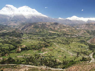 Cordillera Blanca with debris cone of Ranrahirca
 Late afternoon view from the road between Matacoto and Santo Toribio across the Callejón de Huaylas...") Cordillera Blanca | Nevado Huascarán
Cordillera Blanca | Nevado Huascarán View from the road between Matacoto and Santo Toribio across the Callejón de Huaylas in E direction...") Cordillera Blanca | Nevado Huascarán at sunset
Cordillera Blanca | Nevado Huascarán at sunset View from the slopes of the Cordillera Negra to the highest tropical mountain worldwide (6768 m). Th...") Callejón de Huaylas with Nevado Huascarán
Callejón de Huaylas with Nevado Huascarán View from the slopes of the Cordillera Negra to the highest tropical mountain worldwide (6768 m). Th...") Callejón de Huaylas with Nevado Huascarán
Callejón de Huaylas with Nevado Huascarán Nueva Yungay (left portion of the image) was founded after the original town had been destroyed by a...") Callejón de Huaylas | Nueva Yungay and Campo Santo
Callejón de Huaylas | Nueva Yungay and Campo Santo Campo Santo represents the site of the original town of Yungay, which was destroyed on 31 May 1970 w...") Yungay | Campo Santo
Yungay | Campo Santo View from the cemetery hill in NE direction. Campo Santo represents the site of the original town of...") Yungay | Campo Santo with Nevado Huascarán
Yungay | Campo Santo with Nevado Huascarán Various crops are cultivated at an elevation of approx. 3200 m asl. between Yungay and the Lagunas d...") Huashao | Farmland
Huashao | Farmland View from the vicinity of Laguna 513 across the Callejón de Huaylas in SW direction to the Cordille...") Quebrada Hualcán with Polylepis forest
Quebrada Hualcán with Polylepis forest Trees of the genus Polylepis can form forest patches at 4500 m asl. or even higher.") Quebrada Hualcán | Polylepis sp.
Quebrada Hualcán | Polylepis sp. View from the Ishinca Trek in SW direction") Quebrada Ishinca and Cordillera Negra
Quebrada Ishinca and Cordillera Negra In the Cordillera Blanca, trees of the genus Polylepis can survive at 4500 m asl. or even higher. Wh...") Quebrada Ishinca | Polylepis forest
Quebrada Ishinca | Polylepis forest In the Cordillera Blanca, trees of the genus Polylepis can survive at 4500 m asl. or even higher. Wh...") Quebrada Ishinca | Polylepis forest patch
Quebrada Ishinca | Polylepis forest patch Ishinca Trek with international visitors heading towards the Refugio Ishinca. Tocllaraju (6034 m) ap...") Quebrada Ishinca with Tocllaraju
Quebrada Ishinca with Tocllaraju This mountain hut and the surrounding camp site are located at 4350 m asl.") Quebrada Ishinca | Refugio Ishinca
Quebrada Ishinca | Refugio Ishinca The debris cone in the left part of this photograph dates back to 1952. It is the result of an outbu...") Quebrada Ishinca | Panoramic view
Quebrada Ishinca | Panoramic view Plants need to develop specific strategies if they want to survive in the harsh climate at 5000 m as...") Quebrada Ishinca | Cushion plant
Quebrada Ishinca | Cushion plant View from the rooftop of the Universidad Nacional Santiago Antúnez de Mayolo (UNASAM) over the city...") Huaraz | City centre
Huaraz | City centre View from the rooftop of the Universidad Nacional Santiago Antúnez de Mayolo (UNASAM) in E directio...") Huaraz | Urban landscape
Huaraz | Urban landscape View from the slopes of the Cordillera Negra over Huaraz in E direction to the valleys of the Quilca...") Huaraz with Cordillera Blanca
Huaraz with Cordillera Blanca View from the slopes of the Cordillera Negra over Huaraz in E direction to the valleys of the Quilca...") Huaraz | Panoramic view with Cordillera Blanca
Huaraz | Panoramic view with Cordillera Blanca Panoramic view from the trail to Laguna Churup across the Callejón de Huaylas with Huaraz in SW dir...") Callejón de Huaylas with Huaraz and Cordillera Negra
Callejón de Huaylas with Huaraz and Cordillera Negra Panoramic view from the trail to Laguna Churup across the Callejón de Huaylas with Huaraz in W dire...") Quebrada Quilcayhuanca with pine plantation
Quebrada Quilcayhuanca with pine plantation View from the trail to Laguna Churup across the Callejón de Huaylas with Huaraz in SW direction to ...") Callejón de Huaylas with Huaraz and Cordillera Negra
Callejón de Huaylas with Huaraz and Cordillera Negra Panoramic view from the trail to Laguna Churup across the Callejón de Huaylas in NW direction to th...") Callejón de Huaylas | Mina Pierina
Callejón de Huaylas | Mina Pierina View from the trail to Laguna Churup across the Quebrada Quilcayhuanca in SE direction. The glacieri...") Quebrada Quilcayhuanca and Cashan
Quebrada Quilcayhuanca and Cashan In the Cordillera Blanca, trees of the genus Polylepis can survive at 4500 m asl. or even higher. Wh...") Quebrada Quilcayhuanca | Polylepis
Quebrada Quilcayhuanca | Polylepis The sharp horizontal vegetation boundary in the right centre of this image marks the level of the fo...") Quebrada Cojup | Former Laguna Jircacocha
Quebrada Cojup | Former Laguna Jircacocha View from the former moraine dam of Laguna Palcacocha in SW direction. The bright-coloured debris sp...") Quebrada Cojup | Lake outburst deposits
Quebrada Cojup | Lake outburst deposits Until 13 December 1941, Laguna Palcacocha was impounded behind the horseshoe-shaped moraine ridge se...") Laguna Palcacocha | Panoramic view
Laguna Palcacocha | Panoramic view Panoramic view of a bofedal (high-Andean wetland) along the way to Pastoruri Glacier. The small pond...") Pumapampa with Ojo de Agua de Pumashimi
Pumapampa with Ojo de Agua de Pumashimi Bofedal (high-Andean wetland) along the way to Pastoruri Glacier. This small pond is characterized b...") Pumapampa | Ojo de Agua de Pumashimi
Pumapampa | Ojo de Agua de Pumashimi View from the road to Pastoruri Glacier, bofedal (high-Andean wetland) in the foreground. Elevation:...") Pumapampa | Puna landscape with bofedal
Pumapampa | Puna landscape with bofedal View from the road to Pastoruri Glacier, summit elevation of Nevado Mururaju: 5688 m") Cordillera Blanca | Nevado Mururaju
Cordillera Blanca | Nevado Mururaju Elevation: approx. 4200 m asl. These bromeliad rosette plants develop huge inflorescences (in total,...") Pumapampa | Puya raimondii
Pumapampa | Puya raimondii Elevation: approx. 4200 m asl. These bromeliad rosette plants develop huge inflorescences (in total,...") Pumapampa | Puya raimondii
Pumapampa | Puya raimondii Elevation: approx. 4200 m asl. These bromeliad rosette plants develop huge inflorescences (in total,...") Pumapampa | Puya raimondii
Pumapampa | Puya raimondii Elevation: approx. 4200 m asl. These bromeliad rosette plants develop huge inflorescences (in total,...") Pumapampa | Puya raimondii
Pumapampa | Puya raimondii Elevation: approx. 4200 m asl. These bromeliad rosette plants develop huge inflorescences (in total,...") Pumapampa | Puya raimondii
Pumapampa | Puya raimondii View from the highway Pativilca - Huaraz across the uppermost part of the Callejón de Huaylas in SE...") Conococha | Río Santa and Cordillera Huayhuash
Conococha | Río Santa and Cordillera Huayhuash View from the highway Pativilca - Huaraz in E direction. This lake at slightly above 4000 m asl. is ...") Laguna Conococha
Laguna Conococha Flight Lima - Medellín, view to Laguna Anilcocha (upper part) and Laguna Patón (lower edge of the ...") Oyón | Laguna de Patón and Laguna Anilcocha
Oyón | Laguna de Patón and Laguna Anilcocha Flight Lima - Medellín. The lake on the left side is Laguna Tinyag, and the adjacent mining site be...") Oyón | Laguna Tinyag and Mina Iscaycruz
Oyón | Laguna Tinyag and Mina Iscaycruz View from Mirador de Antahuilque in NW (downstream) direction. The Colca Valley has been inhabited s...") Valle del Colca with Madrigal
Valle del Colca with Madrigal View from Mirador de Wayrac Punku in E (upstream) direction. The Colca Valley has been inhabited sin...") Valle del Colca | Panoramic view with Madrigal
Valle del Colca | Panoramic view with Madrigal View from Mirador de Wayrac Punku in NE direction. This section of the Colca Valley has been influen...") Valle del Colca | Panoramic view with Madrigal
Valle del Colca | Panoramic view with Madrigal View from Mirador de Wayrac Punku in NE direction. This section of the Colca Valley has been influen...") Valle del Colca with landslide of Madrigal
Valle del Colca with landslide of Madrigal View from Mirador de Wayrac Punku in NE direction. This section of the Colca Valley has been influen...") Valle del Colca | Landslide of Madrigal in 2018
Valle del Colca | Landslide of Madrigal in 2018 View from Mirador de Wayrac Punku in NE direction. This section of the Colca Valley has been influen...") Valle del Colca | Landslide of Madrigal in 2022
Valle del Colca | Landslide of Madrigal in 2022 View from Mirador de Wayrac Punku in E (upstream) direction. The Colca Valley has been inhabited sin...") Valle del Colca with terraced farmland
Valle del Colca with terraced farmland View in NW (downstream) direction. The Colca Valley has been inhabited since pre-Incan times, so tha...") Valle del Colca
Valle del Colca View in W (downstream) direction. This massive outcrop of bright, predominantly fine-grained pyrocla...") Valle del Colca with pyroclastic deposit
Valle del Colca with pyroclastic deposit View from Mirador de Antahuilque in NE direction. The Colca Valley has been inhabited since pre-Inca...") Valle del Colca | Panoramic view with Madrigal and Lari
Valle del Colca | Panoramic view with Madrigal and Lari View from Mirador de Antahuilque in NE (upstream) direction. The Colca Valley has been inhabited sin...") Valle del Colca | Panoramic view with Lari
Valle del Colca | Panoramic view with Lari View from Mirador de Antahuilque in E (upstream) direction. The Colca Valley has been inhabited sinc...") Valle del Colca | Panoramic view with Lari and Maca
Valle del Colca | Panoramic view with Lari and Maca The Colca Valley has been inhabited since pre-Incan times, so that ancient terraced farmlands are ch...") Valle del Colca | Terraced farmland
Valle del Colca | Terraced farmland View in N direction. The Colca Valley has been inhabited since pre-Incan times, so that ancient terr...") Valle del Colca | Panoramic view with terraced farmland
Valle del Colca | Panoramic view with terraced farmland View in E (upstream) direction. This section of the Colca Valley has been influenced by earthquakes,...") Valle del Colca | Landslide of Maca
Valle del Colca | Landslide of Maca