

 Panoramic view from Miradouro do Portal along the rugged W coast of Flores and up the basin of Fajã...") Flores | West coast and basin of Fajãzinha
Flores | West coast and basin of Fajãzinha View from Miradouro do Portal up the basin of Fajãzinha (the village of the same name appears near ...") Flores | Basin of Fajãzinha
Flores | Basin of Fajãzinha Panoramic view from Miradouro Craveiro Lopes in NW direction over the basin of Fajãzinha and to the...") Flores | Basin of Fajãzinha and west coast
Flores | Basin of Fajãzinha and west coast View from Miradouro Craveiro Lopes in NW direction to the basin of Fajãzinha, bounded by steep esca...") Flores | Basin of Fajãzinha with Poço da Ribeira do Ferreiro
Flores | Basin of Fajãzinha with Poço da Ribeira do Ferreiro Panoramic view along the comparatively sunny S coast in W direction. Repeated landslides from the cl...") Flores | South coast with Fajã de Lopo Vaz
Flores | South coast with Fajã de Lopo Vaz View along the comparatively sunny S coast of Flores in W direction. Landslides from the cliffs have...") Flores | South coast with Fajã de Lopo Vaz
Flores | South coast with Fajã de Lopo Vaz View along the comparatively sunny S coast of Flores in W direction. Landslides from the cliffs have...") Flores | Fajã de Lopo Vaz and Ponta da Rocha Alta
Flores | Fajã de Lopo Vaz and Ponta da Rocha Alta View along the comparatively sunny S coast of Flores in W direction. Repeated landslides from the sh...") Flores | Fajã de Lopo Vaz
Flores | Fajã de Lopo Vaz View along the comparatively sunny S coast of Flores in W direction. Repeated landslides from the sh...") Flores | Fajã de Lopo Vaz
Flores | Fajã de Lopo Vaz View from the ferry connecting Pico and Faial in NW direction to the steep coastal cliff at Ponta da...") Ponta da Espalamaca with Vulcão da Caldeira
Ponta da Espalamaca with Vulcão da Caldeira Steep coastal cliff at Ponta da Espalamaca with clear signs of a recent rock fall event, most probab...") Ponta da Espalamaca | Rock fall
Ponta da Espalamaca | Rock fall View along the N part of the rim of the caldera forming the very centre of Faial. The cauldron is mo...") Vulcão da Caldeira | Caldera rim
Vulcão da Caldeira | Caldera rim View down the N slope of Montanha do Pico. The summit crater Pico Alto ends in a sheer cliff. Most l...") Montanha do Pico | Northern slope
Montanha do Pico | Northern slope Railways in Argentina have seen better times. This part of the trans-Andean railway line - abandoned...") Valle Mendoza | Railway covered by debris flow
Valle Mendoza | Railway covered by debris flow Railways in Argentina have seen better times. This bridge of the trans-Andean railway line - abandon...") Valle Mendoza | Rail bridge with debris flow
Valle Mendoza | Rail bridge with debris flow Railways in Argentina have seen better times. This bridge of the trans-Andean railway line - abandon...") Valle Mendoza | Rail bridge with debris flow
Valle Mendoza | Rail bridge with debris flow National Road 7 and Río Mendoza are shown in the background.") Valle Mendoza | Debris flow path near Guido
Valle Mendoza | Debris flow path near Guido Location: Arroyo El Tigre. A massive debris flow related to a localized heavy rainfall event destroy...") Valle Mendoza | Collapsed rail bridge
Valle Mendoza | Collapsed rail bridge Location: Arroyo El Tigre. A massive debris flow related to a localized heavy rainfall event destroy...") Valle Mendoza | Collapsed rail bridge
Valle Mendoza | Collapsed rail bridge Location: Arroyo El Tigre. A massive debris flow related to a localized heavy rainfall event destroy...") Valle Mendoza | Collapsed rail bridge
Valle Mendoza | Collapsed rail bridge A massive debris flow related to a localized heavy rainfall event destroyed the former rail bridge a...") Valle Mendoza | Arroyo El Tigre with collapsed rail bridge
Valle Mendoza | Arroyo El Tigre with collapsed rail bridge Location: Arroyo El Tigre. A massive debris flow related to a localized heavy rainfall event has des...") Valle Mendoza | Destroyed road bridge
Valle Mendoza | Destroyed road bridge Arroyo El Tigre. A debris flow related to heavy rainfall had destroyed the bridge of the National Ro...") Valle Mendoza | Reconstructed road bridge
Valle Mendoza | Reconstructed road bridge View downstream") Valle Mendoza | Geodiversity near Polvaredas
Valle Mendoza | Geodiversity near Polvaredas View downstream") Valle Mendoza | Geodiversity near Polvaredas
Valle Mendoza | Geodiversity near Polvaredas At this site between Polvaredas and Punta de Vacas, there is evidence that landslides from both side...") Valle Mendoza | Amarillo and Negro landslides
Valle Mendoza | Amarillo and Negro landslides At this site between Polvaredas and Punta de Vacas, there is evidence that landslides from both side...") Polvaredas | Amarillo landslide
Polvaredas | Amarillo landslide View from the road to Paso Bermejo. Note the deposits of the Cerro Tolosa rock avalanches in the lef...") Valle Mendoza | Las Cuevas
Valle Mendoza | Las Cuevas View from the road to Paso Bermejo. Note the deposits of the prehistoric Cerro Tolosa rock avalanche...") Valle Mendoza | Cerro Tolosa rock avalanches
Valle Mendoza | Cerro Tolosa rock avalanches Location: Las Cuevas") Valle Mendoza | Cerro Tolosa rock avalanches
Valle Mendoza | Cerro Tolosa rock avalanches Location: Las Cuevas") Valle Mendoza | Cerro Tolosa rock avalanches
Valle Mendoza | Cerro Tolosa rock avalanches Location: Las Cuevas, late afternoon view") Valle Mendoza | Cerro Tolosa rock avalanches
Valle Mendoza | Cerro Tolosa rock avalanches The small village of Las Cuevas once served as a railway station close to the Argentine-Chilean bord...") Valle Mendoza | Las Cuevas panorama
Valle Mendoza | Las Cuevas panorama The mountain in the background of this photo consists of a sequence of sedimentary rocks, including ...") Valle Mendoza | Laguna de los Horcones
Valle Mendoza | Laguna de los Horcones View from Horcones in NW direction to America's highest peak (6961 m). The hummocky surface in the f...") Horcones and Aconcagua
Horcones and Aconcagua View from Horcones in NW direction to America's highest peak (6961 m). The hummocky surface at the b...") Aconcagua
Aconcagua View from Horcones in NW direction to America's highest peak (6961 m). The hummocky surface in the f...") Horcones and Aconcagua
Horcones and Aconcagua Erosion gully in the area of La Yesera. The deposit of the prehistoric El Paso landslides is shown i...") Quebrada de Las Conchas | Gully erosion
Quebrada de Las Conchas | Gully erosion Panoramic view of a landscape created by at least two prehistoric landslides. The hills on the left ...") Quebrada de Las Conchas | El Paso landslides
Quebrada de Las Conchas | El Paso landslides This landslide became active at the end of April 2023, after a rainy period. It resulted in evacuati...") Hörbranz | Landslide
Hörbranz | Landslide This landslide became active at the end of April 2023, after a rainy period. It resulted in evacuati...") Hörbranz | Landslide
Hörbranz | Landslide This landslide became active at the end of April 2023, after a rainy period. It resulted in evacuati...") Hörbranz | Landslide
Hörbranz | Landslide This block field in a forest at the W slope of Hittisberg is the result of a prehistoric rock avalan...") Hittisau | Rappenfluh
Hittisau | Rappenfluh View from the Winterstaude mountain chain over the Bregenz forest with the villages of Langenegg and...") Bregenzerwald with Doren
Bregenzerwald with Doren View from the Winterstaude mountain chain over the Bregenz forest with the villages of Egg, Lingenau...") Bregenzerwald with Lingenau and Hittisau
Bregenzerwald with Lingenau and Hittisau This image was taken one week after a chunk of rock of approx. 1 million cubic metres had detached f...") Silvretta | Fluchthorn with landslide scarp
Silvretta | Fluchthorn with landslide scarp This photo was taken one week after a chunk of rock of approx. 1 million cubic metres had detached f...") Silvretta | Fluchthorn with traces of rock avalanche
Silvretta | Fluchthorn with traces of rock avalanche This photo was taken one week after a chunk of rock of approx. 1 million cubic metres had detached f...") Silvretta | Fluchthorn with traces of process chain
Silvretta | Fluchthorn with traces of process chain This photo was taken one week after a chunk of rock of approx. 1 million cubic metres had detached f...") Silvretta | Fluchthorn with traces of process chain
Silvretta | Fluchthorn with traces of process chain This photo was taken one week after a chunk of rock of approx. 1 million cubic metres had detached f...") Silvretta | Furtschöltal with Fluchthorn
Silvretta | Furtschöltal with Fluchthorn This photo was taken one week after a chunk of rock of approx. 1 million cubic metres had detached f...") Silvretta | Furtschöltal with traces of debris flow
Silvretta | Furtschöltal with traces of debris flow The hamlet of Gries was badly affected by a debris flow in the night of 6-7 June 2015. The amount of...") See im Paznauntal | Debris flow impact
See im Paznauntal | Debris flow impact The hamlet Gries after a debris flow in the night of 6-7 June 2015. The amount of material transport...") See im Paznauntal | Debris flow impact
See im Paznauntal | Debris flow impact The hamlet of Gries was badly affected by a debris flow in the night of 6-7 June 2015. The amount of...") See im Paznauntal | Debris flow impact
See im Paznauntal | Debris flow impact The hamlet Gries after a debris flow in the night of 6-7 June 2015. The amount of material transport...") See im Paznauntal | Debris flow impact
See im Paznauntal | Debris flow impact The house in the right foreground is one of several buildings in the hamlet of Gries badly affected ...") See im Paznauntal | Debris flow impact
See im Paznauntal | Debris flow impact The slopes heading into the Gepatsch reservoir are characterized by scarps indicating a system of sl...") Kaunertal | Gepatsch Stausee
Kaunertal | Gepatsch Stausee The slopes heading into the Gepatsch reservoir are characterized by scarps indicating a system of sl...") Kaunertal | Gepatsch Stausee with Hochmais landslide
Kaunertal | Gepatsch Stausee with Hochmais landslide Location: Hühnerspiel, NE slope of Pleisspitze. This scene shows a textbook example of a debris flo...") Forchach | Debris flow
Forchach | Debris flow Location: Hühnerspiel, NE slope of Pleisspitze. Also this photo depicts a textbook example of a deb...") Forchach | Debris flow
Forchach | Debris flow Panoramic view from Wannig in N direction. The basin of Ehrwald and the Zugspitze (2962 m) can be se...") Fernpass rock avalanche
Fernpass rock avalanche Panoramic view from the ridge between Grubigstein and Gartnerwand in S direction. The deposit of the...") Fernpass rock avalanche
Fernpass rock avalanche The lake fills a depression in the hummocky deposit of the Fernpass rock avalanche, a long-runout la...") Lermoos | Blindsee
Lermoos | Blindsee The lake fills a depression in the hummocky deposit of the Fernpass rock avalanche, a long-runout la...") Nassereith | Fernsteinsee
Nassereith | Fernsteinsee The lake fills a depression in the hummocky deposit of the Fernpass rock avalanche, a long-runout la...") Nassereith | Fernsteinsee
Nassereith | Fernsteinsee Panoramic view from Blose in N direction. The deposits S of Tschirgant (centre of the photo, 2372 m)...") Inntal with Tschirgant rock avalanche
Inntal with Tschirgant rock avalanche View from Blose in N direction. The deposits S of Tschirgant (centre of the image, 2372 m), blocking...") Inntal with Tschirgant rock avalanche
Inntal with Tschirgant rock avalanche Location: near Ambach. The eroded deposit in the forground consists of rock commonly found in the No...") Tschirgant rock avalanche
Tschirgant rock avalanche Scots pine (Pinus sylvestris) forest occupying the deposit of the prehistoric Tschirgant rock avalan...") Tschirgant rock avalanche | Deposit with pine forest
Tschirgant rock avalanche | Deposit with pine forest Erica carnea in the undergrowth of a scots pine (Pinus sylvestris) forest occupying the deposit of t...") Tschirgant rock avalanche | Deposit with pine forest
Tschirgant rock avalanche | Deposit with pine forest Erica carnea in the undergrowth of the scots pine (Pinus sylvestris) forest occupying the deposit of...") Tschirgant rock avalanche | Deposit with heather
Tschirgant rock avalanche | Deposit with heather View from Hohe Warte in NW direction to the Tumpen rock avalanche (deposit in the central forground)...") Ötztal with rock avalanches
Ötztal with rock avalanches Viewpoint near the summit of Wenderkogel. Farst and the deposit of the Tumpen rock avalanche are sho...") Ötztal with Tumpen rock avalanche
Ötztal with Tumpen rock avalanche Scots pine (Pinus sylvestris) forest occupying the deposit of the prehistoric Köfels rock slide nea...") Köfels rock slide | Deposit with pine forest
Köfels rock slide | Deposit with pine forest View from Köfels to the distal part of the deposit of the prehistoric rock slide of the same name") Köfels rock slide | Deposit
Köfels rock slide | Deposit View from Breite Lahn, forming part of the scarp of the prehistoric Köfels rock slide. The Ötztale...") Köfels rock slide | Deposit
Köfels rock slide | Deposit View from Breite Lahn, forming part of the scarp of the prehistoric Köfels rock slide which blocked...") Köfels rock slide | Panorama
Köfels rock slide | Panorama Viewpoint near the summit of Wenderkogel. The prehistoric Köfels rock slide blocked the valley and ...") Köfels rock slide | Panorama
Köfels rock slide | Panorama View from Hemerkogel. The prehistoric Köfels rock slide, originating from the opposite slope, block...") Ötztal | Panoramic view with Köfels rock slide
Ötztal | Panoramic view with Köfels rock slide View from Hemerkogel. The prehistoric Köfels rock slide, originating from the opposite slope, block...") Ötztal with Köfels rock slide
Ötztal with Köfels rock slide View from the summit area of Patscherkofel in E direction to Viggarspitze (2306 m) in the centre and...") Tuxer Alpen with Viggarspitze and Glungezer
Tuxer Alpen with Viggarspitze and Glungezer View from the summit area of Patscherkofel in E direction to Viggarspitze (right side, 2306 m) and a...") Tuxer Alpen | Viggarspitze
Tuxer Alpen | Viggarspitze View from Viggarspitze in NW direction to Patscherkofel (2246 m). The metamorphic rocks forming this...") Tuxer Alpen with Patscherkofel
Tuxer Alpen with Patscherkofel Location: near the summit of Patscherkofel (2246 m), view in NE direction. The back scarp in the for...") Tuxer Alpen | Back scarp and Inntal
Tuxer Alpen | Back scarp and Inntal The slow-moving landslide is visible in the centre of the image.") Rofan | Ludoialm landslide
Rofan | Ludoialm landslide Uppermost scarp of the landslide system") Rofan | Ludoialm landslide
Rofan | Ludoialm landslide So-called \"drunken forests\" indicate a certain degree of slope movement.") Rofan | Ludoialm landslide
Rofan | Ludoialm landslide This shallow landslide, converting into an earth flow, was caused by intense rainfall in late spring...") Kirchdorf in Tirol | Shallow landslide with earth flow
Kirchdorf in Tirol | Shallow landslide with earth flow This rock slide destroyed a protection tunnel of the Felbertauern Highway on May 14, 2013 without ca...") Felbertauern | Schildalmgalerie Rock Slide panorama
Felbertauern | Schildalmgalerie Rock Slide panorama Rock slide of May 14, 2013 with destroyed protection tunnel of the Felbertauern Highway") Felbertauern | Schildalmgalerie Rock Slide
Felbertauern | Schildalmgalerie Rock Slide Release area of the rock slide of May 14, 2013 with stabilization measures") Felbertauern | Schildalmgalerie Rock Slide
Felbertauern | Schildalmgalerie Rock Slide Destroyed protection tunnel of the Felbertauern Highway") Felbertauern | Schildalmgalerie Rock Slide
Felbertauern | Schildalmgalerie Rock Slide Rock slide of May 14, 2013 with destroyed protection tunnel of the Felbertauern Highway") Felbertauern | Schildalmgalerie Rock Slide
Felbertauern | Schildalmgalerie Rock Slide") Froßnitztal | Slope deformation with backscarp
Froßnitztal | Slope deformation with backscarp The South face of Dobratsch is a geomorphologically highly active zone, with frequent rock falls and...") Dobratsch | South face with Schütt
Dobratsch | South face with Schütt This rock slide deposit is one of the last refugia of Gladiolus illyricus in central Europe.") Schütt | Illyric gladiolus
Schütt | Illyric gladiolus Rock fall scar on the SE side of Topitza (1649 m)") Topitza | Rock fall scar
Topitza | Rock fall scar This complex landslide at the E side of Topitza is connected to a geological hard-on-soft situation:...") Topitza | Rock fall and earth flow
Topitza | Rock fall and earth flow This complex landslide at the E side of Topitza is connected to a geological hard-on-soft situation:...") Topitza | Rock fall and earth flow
Topitza | Rock fall and earth flow The complex landslide in the foreground of this image (E side of the Topitza mountain) is connected ...") Topitza | Rock fall and earth flow
Topitza | Rock fall and earth flow Morning view from Trenchtling in NE direction to the Pribitz (1579 m, centre) and the Messnerin (183...") Tragöß | Hochschwab panorama with Grüner See
Tragöß | Hochschwab panorama with Grüner See View from Trenchtling in NE direction to the Messnerin (1835 m). An ancient rock avalanche from the ...") Tragöß | Messnerin and Grüner See
Tragöß | Messnerin and Grüner See The Grüner See (Green Lake) was impounded by an ancient landslide originating from the slopes of Me...") Tragöß | Grüner See
Tragöß | Grüner See The Grüner See (Green Lake) was impounded by an ancient landslide originating from the slopes of Me...") Tragöß | Grüner See
Tragöß | Grüner See The Grüner See (Green Lake) was impounded by an ancient landslide originating from the slopes of Me...") Tragöß | Grüner See with Trenchtling
Tragöß | Grüner See with Trenchtling The Grüner See (Green Lake) was impounded by an ancient landslide originating from the slopes of Me...") Tragöß | Grüner See with Trenchtling
Tragöß | Grüner See with Trenchtling The Grüner See (Green Lake) was impounded by an ancient landslide originating from the slopes of Me...") Tragöß | Grüner See with Trenchtling
Tragöß | Grüner See with Trenchtling The Grüner See (Green Lake) was impounded by an ancient landslide originating from the slopes of Me...") Tragöß | Grüner See
Tragöß | Grüner See The Grüner See (Green Lake) was impounded by an ancient landslide originating from the slopes of Me...") Tragöß | Grüner See with Pribitz
Tragöß | Grüner See with Pribitz The Grüner See (Green Lake) was impounded by an ancient landslide originating from the slopes of Me...") Tragöß | Grüner See with Pribitz
Tragöß | Grüner See with Pribitz The smaller counterpart to the Grüner See is also located in the area affected by the prehistoric r...") Tragöß | Pfarrerteich with Pribitz
Tragöß | Pfarrerteich with Pribitz View from Ebenstein over the deposit of the prehistoric Wildalpen rock avalanche in NW direction. Th...") Wildalpen | Rock avalanche panorama
Wildalpen | Rock avalanche panorama The giant Wildalpen rock avalanche, involving approx. 900 million cubic metres of limestone, occurre...") Wildalpen | Sliding surface of rock avalanche
Wildalpen | Sliding surface of rock avalanche The giant Wildalpen rock avalanche, involving approx. 900 million cubic metres of limestone, occurre...") Wildalpen | Sliding surface of rock avalanche
Wildalpen | Sliding surface of rock avalanche The giant Wildalpen rock avalanche, involving approx. 900 million cubic metres of limestone, occurre...") Wildalpen | Sliding surface with karren
Wildalpen | Sliding surface with karren Deposition area of the Wildalpen rock avalanche. This giant landslide of approx. 900 million cubic m...") Wildalpen | Rock avalanche deposit
Wildalpen | Rock avalanche deposit Deposition area of the Wildalpen rock avalanche. This giant landslide of approx. 900 million cubic m...") Wildalpen | Rock avalanche deposit
Wildalpen | Rock avalanche deposit View in eastern direction to one of various debris flow channels heading down from the steep limesto...") Gesäuse | Johnsbach Valley with Hochtor
Gesäuse | Johnsbach Valley with Hochtor One of various debris flow channels heading down from the steep limestone and dolomite slopes and cl...") Johnsbach Valley | Debris flow gully
Johnsbach Valley | Debris flow gully The Rohrleitengraben has repeatedly been the scene of earth flows, originating from marls loosing th...") Weyregg am Attersee | Rohrleitengraben
Weyregg am Attersee | Rohrleitengraben The Rohrleitengraben near Weyregg has repeatedly been the scene of earth flows, originating from mar...") Weyregg am Attersee | Split tree trunk
Weyregg am Attersee | Split tree trunk View from Rossatz across the Danube to a rock fall area near Dürnstein. The Wachau represents a rel...") Wachau | Rock fall area
Wachau | Rock fall area Sand flows") Imperial Valley | Imperial Dune Field
Imperial Valley | Imperial Dune Field View from the slopes of Prutaš to the SW part of the Durmitor mountains with Ružica (2141 m). The ...") Durmitor | Karst highland with Ružica
Durmitor | Karst highland with Ružica View from Varen in SE direction to the large debris cone of the Illgraben, representing a very activ...") Rhone Valley with Pfynwald
Rhone Valley with Pfynwald View from the road Leuk - Erschmatt in SW direction to the Illgraben with its large debris cone. The...") Rhone Valley with Pfynwald
Rhone Valley with Pfynwald View from Niwenalp in SW direction to the Illgraben with its large debris cone. The Illgraben repres...") Rhone Valley with Pfynwald and Illgraben
Rhone Valley with Pfynwald and Illgraben View from Bhutan Bridge down to the flow channel incised into the debris cone at the outlet of Illgr...") Leuk | Illgraben torrent
Leuk | Illgraben torrent Late afternoon view from the Kapellenweg across the Rhone Valley in NW direction. This classic examp...") Raron | Landslide
Raron | Landslide View from Jungen in SE direction. The Ritigraben represents a very active and intensively researched...") Matter Valley with Ritigraben
Matter Valley with Ritigraben The Ritigraben represents a very active and intensively researched debris flow channel. Debris flows...") Matter Valley | Ritigraben with damaged tree
Matter Valley | Ritigraben with damaged tree The Ritigraben represents a very active and intensively researched debris flow channel. Debris flows...") Matter Valley | Ritigraben
Matter Valley | Ritigraben The Ritigraben represents a very active and intensively researched debris flow channel. Debris flows...") Matter Valley | Ritigraben
Matter Valley | Ritigraben The Ritigraben represents a very active and intensively researched debris flow channel. Debris flows...") Matter Valley | Rock glacier at top of Ritigraben
Matter Valley | Rock glacier at top of Ritigraben View from Riffelberg in N direction down to the Matter Valley with Zermatt. The most notable summits...") Zermatt | Matter Valley with mountain panorama
Zermatt | Matter Valley with mountain panorama View from Riffelberg in N direction down the Matter Valley to the Bernese Alps with the Bietschhorn ...") Zermatt | Matter Valley with Randa Rock Slide
Zermatt | Matter Valley with Randa Rock Slide This landslide occurred in two main stages in spring 1991. During both stages, the material was rele...") Matter Valley | Randa Rock Slide
Matter Valley | Randa Rock Slide Prehistoric rock slide which blocked the Saaser Vispa in ancient times. The village of Saas-Almagell...") Saas Valley | Landslide and Saas-Almagell
Saas Valley | Landslide and Saas-Almagell View from the vicinity of Mund across the Rhone Valley to Glishorn (2525 m) and Fülhorn (2678 m). T...") Brig | Glishorn with ancient landslide
Brig | Glishorn with ancient landslide The system of backscarps clearly indicates deep-seated gravitational slope deformation processes goi...") Fiescheralp | Slope deformation
Fiescheralp | Slope deformation One of various backscarp features on the SE slope of Nägelisgrätli, indicating a deep-seated gravi...") Nägelisgrätli | Slope movements
Nägelisgrätli | Slope movements Panoramic view from Nägelisgrätli in NE direction. The slopes in the centre of the photo are chara...") Nägelisgrätli and Gärstenhörner
Nägelisgrätli and Gärstenhörner Location: near Kleine Scheidegg, view from Lauberhorn") Grindelwald | Slope deformation
Grindelwald | Slope deformation One of the most famous panoramas of the Alps: view from the Lauberhorn in SE direction to the Eiger ...") Eiger Mönch Jungfrau panorama
Eiger Mönch Jungfrau panorama View from Rigi Scheidegg. Centre of the image: rock slide from the south slope of Rossberg (1580 m) ...") Goldau Landslide panorama
Goldau Landslide panorama The Tamins Rock Avalanche in the centre of the photo, which occurred more than 9500 years before pre...") Rheintal Valley with Flims-Tamins System
Rheintal Valley with Flims-Tamins System The Tamins Rock Avalanche, which occurred more than 9500 years before present, dammed a lake which w...") Domat | Toma hills
Domat | Toma hills View from the slopes of Dreibündenstein. Bonaduz is visible in the central foreground, the rock sli...") Flims Rock Slide panorama
Flims Rock Slide panorama The rocks represent the distal part of the deposit of the Flims Rock Slide. They are still found in ...") Versamer Tobel | Rock slide deposit
Versamer Tobel | Rock slide deposit View towards west, the viewing platform Il Spir near Conn is seen in the upper right part of the ima...") Flims Rock Slide | Ruinaulta
Flims Rock Slide | Ruinaulta View from the viewing platform Il Spir near Conn. The Vorderrhein River has eroded a deep gorge (the...") Flims Rock Slide | Ruinaulta
Flims Rock Slide | Ruinaulta View from the slopes of Dutjer Horn. Note the gorge eroded through the rock slide deposit by the Vor...") Flims Rock Slide panorama
Flims Rock Slide panorama The lake is embedded in the deposit of the Flims Rock Slide.") Flims Rock Slide | Lag da Cauma
Flims Rock Slide | Lag da Cauma View from Grauberg over the release area of the rock slide. Flimserstein is seen in the central, the...") Flims Rock Slide | Release area
Flims Rock Slide | Release area View from the trail Segneshütte - Fil de Cassons towards south. The bare rock in the foreground may...") Flims Rock Slide | Sliding surface
Flims Rock Slide | Sliding surface Panoramic view from the road Mon - Salouf across the Albula Valley with Tiefencastel in N direction....") Albula Valley with Piz Linard and Brienz
Albula Valley with Piz Linard and Brienz View from the road Mon - Salouf across the Albula Valley with Tiefencastel (central bottom) in NE di...") Piz Linard with rock avalanche and Brienz
Piz Linard with rock avalanche and Brienz View from the road Mon - Salouf in NE direction to the lower S slope of Piz Linard. The picture was ...") Albula Valley | Brienz with rock avalanche
Albula Valley | Brienz with rock avalanche View from the road Mon - Salouf in NE direction to the village of Brienz. The photo was taken less t...") Albula Valley | Brienz with rock avalanche deposit
Albula Valley | Brienz with rock avalanche deposit View from the road Mon - Salouf in NE direction to the village of Brienz. The scene is depicted less...") Albula Valley | Brienz with rock avalanche deposit
Albula Valley | Brienz with rock avalanche deposit View from the vicinity of Mon in NE direction to the lower S slope of Piz Linard. The picture was ta...") Albula Valley | Brienz with rock avalanche deposit
Albula Valley | Brienz with rock avalanche deposit View from the vicinity of Mon in NE direction to the lower S slope of Piz Linard. The photo shows th...") Albula Valley | Brienz with rock avalanche
Albula Valley | Brienz with rock avalanche View from the vicinity of Mon in NE direction to the lower S slope of Piz Linard. The image shows th...") Albula Valley | Brienz with rock avalanche
Albula Valley | Brienz with rock avalanche View from the vicinity of Mon in NE direction to the lower S slope of Piz Linard and up the Albula V...") Albula Valley with Brienz and rock avalanche
Albula Valley with Brienz and rock avalanche View from the vicinity of Mon (shown in the foreground) in NE direction to the lower S slope of Piz ...") Albula Valley with Mon and rock avalanche of Brienz
Albula Valley with Mon and rock avalanche of Brienz View from the vicinity of Mon (right foreground) in NE direction to the lower S slope of Piz Linard ...") Albula Valley with Mon and rock avalanche of Brienz
Albula Valley with Mon and rock avalanche of Brienz") Flueelapass | Debris flow from rock glacier
Flueelapass | Debris flow from rock glacier Panoramic view down the S slopes of Volcán Osorno. A lahar channel leads all the way down to the va...") Lago Llanquihue and Volcán Calbuco
Lago Llanquihue and Volcán Calbuco Panoramic view down the S slopes of Volcán Osorno with a lahar channel leading all the way down to ...") Volcán Osorno with lahar channel
Volcán Osorno with lahar channel View of the E side of the stratovolcano Osorno (2652 m), which last erupted in 1849. The foreground ...") PN Vicente Pérez Rosales | Volcán Osorno
PN Vicente Pérez Rosales | Volcán Osorno View of the E side of Volcán Osorno (2652 m), which last erupted in 1849. The channel in the right ...") PN Vicente Pérez Rosales with Volcán Osorno
PN Vicente Pérez Rosales with Volcán Osorno This channel at the E footslope of Volcán Osorno illustrates the interplay between erosion and depo...") PN Vicente Pérez Rosales | Lahar channel
PN Vicente Pérez Rosales | Lahar channel The channel in the foreground illustrates the interplay between erosion and deposition processes rel...") Pucón | Tephra layers
Pucón | Tephra layers Northern side of the 2860 m high stratovolcano Villarrica, known as Rucapillán in the Mapuche langu...") Pucón | Zanjón Seco
Pucón | Zanjón Seco Location: near Baños Morales") Cajón del Maipo | Debris avalanche
Cajón del Maipo | Debris avalanche View from Baños Morales") Cajón del Maipo | Debris avalanche
Cajón del Maipo | Debris avalanche The dam retaining the lake on the left side most likely represents a landslide deposit (release area...") Valle del Aconcagua | Portillo with Laguna del Inca
Valle del Aconcagua | Portillo with Laguna del Inca Portillo is one of the most famous ski resorts of the S hemisphere. It hosted the Alpine World Ski C...") Valle del Aconcagua | Portillo with Laguna del Inca
Valle del Aconcagua | Portillo with Laguna del Inca The scar at the slope of this mountain near Machuca, and the deposit downsope, indicate the occurren...") Machuca | Landslide
Machuca | Landslide The Lago de Chungará (4520 m asl.) has been impounded by the deposit of a 6 cubic kilometres large ...") PN Lauca | Lago de Chungará and Volcán Parinacota
PN Lauca | Lago de Chungará and Volcán Parinacota The dormant stratovolcano Parinacota (6348 m) appears on the right side, Volcán Pomerape (6282 m) j...") PN Lauca | Laguna de Cotacotani and Volcán Parinacota
PN Lauca | Laguna de Cotacotani and Volcán Parinacota Even though this lake complex was influenced by a large rock/debris avalanche originating from a vol...") PN Lauca | Laguna de Cotacotani
PN Lauca | Laguna de Cotacotani This lake (4520 m asl.) has been impounded by the deposit of a 6 cubic kilometres large rock/debris ...") PN Lauca | Lago de Chungará
PN Lauca | Lago de Chungará Debris flows in the Hongchun Gully were mobilized as a consequence of numerous landslides triggered ...") Yingxiu | Hongchun Gully with landslide
Yingxiu | Hongchun Gully with landslide A rock avalanche triggered by the Wenchuan Earthquake of May 12, 2008, provided the loose material l...") Yingxiu | Niujuangou Gully
Yingxiu | Niujuangou Gully The Wenjia Landslide in the backgound, with an estimated volume of approx. 27.5 million cubic metres...") Qingping | Wenjia Landslide
Qingping | Wenjia Landslide The Wenjia Landslide, triggered by the Wenchuan Earthquake of May 12, 2008, has mobilized a huge amo...") Qingping | Wenjia Landslide and debris flow
Qingping | Wenjia Landslide and debris flow The Wenjia Landslide, triggered by the Wenchuan Earthquake of May 12, 2008, has mobilized a huge amo...") Qingping | Wenjia Gully debris flow mitigation
Qingping | Wenjia Gully debris flow mitigation The Wenjia Landslide (in the background), triggered by the Wenchuan Earthquake of May 12, 2008, has ...") Qingping | Wenjia Gully debris flow mitigation
Qingping | Wenjia Gully debris flow mitigation This is one of countless mass movements triggered or facilitated by the Wenchuan Earthquake of May 1...") Mianyuan River Valley | Debris flow
Mianyuan River Valley | Debris flow The landslides induced by the Wenchuan Earthquake of May 12, 2008 have mobilized an enormous amount ...") Mianyuan River Valley
Mianyuan River Valley The 1.4 million cubic metres landslide suddenly detached from the slope in the left centre of the im...") Beichuan | Panorama with Wangjiayan Landslide
Beichuan | Panorama with Wangjiayan Landslide The landslide was triggered by the Wenchuan Earthquake (May 12, 2008). It buried the middle school o...") Beichuan | Middle School Landslide
Beichuan | Middle School Landslide Viewpoint near Ngong Ping, cable to Tung Chung New Town in the foreground") Hong Kong | Lan Tau Island with landslides
Hong Kong | Lan Tau Island with landslides View from the cable car Ngong Ping - Tung Chung New Town") Hong Kong | Lan Tau Island with landslides
Hong Kong | Lan Tau Island with landslides View from the highway Ibagué - Melgar") Ricaurte | Landslide
Ricaurte | Landslide View from the road Hobo-Gigante") Upper Río Magdalena valley
Upper Río Magdalena valley View from Popayan - Puracé road") Coconuco | Landslide
Coconuco | Landslide Landslide and debris flow processes affecting the road connecting Liborina and Sabanalarga") La Honda | Landslide and debris flow
La Honda | Landslide and debris flow Debris flow processes affecting the road connecting Liborina and Sabanalarga") La Honda | Debris flow
La Honda | Debris flow View from El Junco across the Río Cauca in W direction to the Cordillera Occidental. Rain shade eff...") Cauca Valley with El Guasimo Landslide
Cauca Valley with El Guasimo Landslide This 225 m high embankment dam on the Cauca River is part of a hydropower project under construction...") Cauca Valley | Hidroituango Dam and Reservoir
Cauca Valley | Hidroituango Dam and Reservoir This 225 m high embankment dam on the Cauca River is part of a hydropower project under construction...") Cauca Valley | Hidroituango Dam and Reservoir
Cauca Valley | Hidroituango Dam and Reservoir This deep-seated landslide is located directly adjacent to the Hidroituango Reservoir, impounded by ...") Cauca Valley | Hidroituango Reservoir with landslide
Cauca Valley | Hidroituango Reservoir with landslide This deep-seated landslide is located directly adjacent to the Hidroituango Reservoir with its 225 m...") Cauca Valley | Landslide with Hidroituango Reservoir
Cauca Valley | Landslide with Hidroituango Reservoir One of various landslides affecting the the road from Medellín to the construction site of the Hidr...") San Andrés Valley | Landslide
San Andrés Valley | Landslide One of various landslides affecting the the road from Medellín to the construction site of the Hidr...") San Andrés Valley | Landslide
San Andrés Valley | Landslide Remediation works at one of the various landslides affecting the the road from Medellín to the cons...") San Andrés Valley | Landslide
San Andrés Valley | Landslide This landslide near San Antonio de Prado happened on 13 July 2022, resulting in two fatalities. Deep...") Quebrada Doña María with landslide
Quebrada Doña María with landslide This landslide near San Antonio de Prado happened on 13 July 2022, resulting in two fatalities. Deep...") Quebrada Doña María | Landslide
Quebrada Doña María | Landslide This landslide near San Antonio de Prado happened on 13 July 2022, resulting in two fatalities. Deep...") Quebrada Doña María | Landslide
Quebrada Doña María | Landslide This landslide near San Antonio de Prado happened on 13 July 2022, resulting in two fatalities. Deep...") Quebrada Doña María | Landslide
Quebrada Doña María | Landslide This landslide near San Antonio de Prado happened on 13 July 2022, resulting in two fatalities. Deep...") Quebrada Doña María | Landslide
Quebrada Doña María | Landslide View from Mirador de El Valle down the Valle de La Orotava in NW direction. This scar of a huge preh...") Valle de La Orotava
Valle de La Orotava View from Mirador de Chipeque across the Valle de La Orotava in W direction. This scar of a huge pre...") Valle de La Orotava and La Palma
Valle de La Orotava and La Palma View from the vicinity of Mirador de Ayosa across the Valle de La Orotava in NW direction. This scar...") Valle de La Orotava and La Palma
Valle de La Orotava and La Palma View from the vicinity of Mirador de Ayosa across the Valle de La Orotava in NW direction. This scar...") Valle de La Orotava and La Palma
Valle de La Orotava and La Palma Humid N side of Tenerife, panoramic view from Mirador de Chipeque across the Valle de La Orotava, re...") Valle de La Orotava and Pico del Teide
Valle de La Orotava and Pico del Teide Humid N side of Tenerife, panoramic view from the vicinity of the Mirador de Ayosa across the Valle ...") Valle de La Orotava and Pico del Teide
Valle de La Orotava and Pico del Teide View from the summit area of Guajara along the escarpment of the cauldron known as Las Cañadas in N...") Las Cañadas with escarpment and Izaña
Las Cañadas with escarpment and Izaña Panoramic view from Guajara in NW direction to the stratovolcano Pico del Teide (3715 m), highest pe...") Las Cañadas and Pico del Teide
Las Cañadas and Pico del Teide Panoramic view from the escarpment in the vicinity of the E of the two summits known as El Sombrero ...") Las Cañadas with Pico Viejo and and Pico del Teide
Las Cañadas with Pico Viejo and and Pico del Teide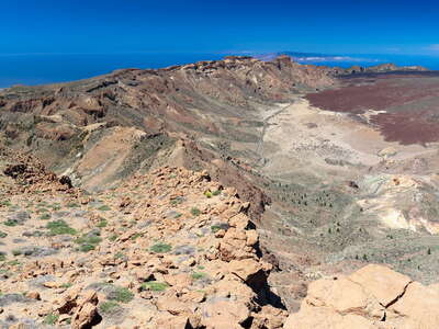 Las Cañadas with escarpment
 View from the summit area of Guajara along the escarpment of the cauldron known as Las Cañadas in S...") Las Cañadas with escarpment
Las Cañadas with escarpment View from the summit area of Guajara along the escarpment of the cauldron known as Las Cañadas in S...") Las Cañadas with El Sombrero and La Gomera
Las Cañadas with El Sombrero and La Gomera Many species of Echium grow as small or medium-sized herbs. In the highlands of Tenerife, Echium wil...") Las Cañadas with Echium wildpretii
Las Cañadas with Echium wildpretii View from the Mirador de la Ruleta across the cauldron of Las Cañadas (the result of prehistoric mo...") Las Cañadas with escarpment
Las Cañadas with escarpment View from the Mirador de las Narices del Teide along the road TF-38 in SE direction. The lava field ...") Las Cañadas with lava field of 1798 and El Sombrero
Las Cañadas with lava field of 1798 and El Sombrero Flight Vienna - Tenerife Sur, view in N direction to the Valle de Güímar, result of a huge prehist...") Valle de Güímar with Malpaís de Güímar
Valle de Güímar with Malpaís de Güímar View from Autopista del Sur in SW direction to the Valle de Güímar, result of a huge prehistoric m...") Autopista del Sur and Valle de Güímar
Autopista del Sur and Valle de Güímar Flight São Filipe - Praia, view to the E slopes and E coast of the volcanic island of Fogo, with th...") Fogo with Pico do Fogo
Fogo with Pico do Fogo Flight São Filipe - Praia, view to the SE slopes and E coast of the volcanic island of Fogo. Lava f...") Fogo with Bordeira and Pico do Fogo
Fogo with Bordeira and Pico do Fogo Flight São Filipe - Praia, view to the S slopes of the volcanic island of Fogo with the village of ...") Fogo with Bordeira and Pico do Fogo
Fogo with Bordeira and Pico do Fogo Flight São Filipe - Praia, view to the S slopes of the volcanic island of Fogo with the village of ...") Fogo with Bordeira and Pico do Fogo
Fogo with Bordeira and Pico do Fogo Panoramic view from a hilltop near the SE corner of the escarpment known as Bordeira across the lava...") Fogo | Bordeira and Pico do Fogo panorama
Fogo | Bordeira and Pico do Fogo panorama Panoramic view from the top of the escarpment (Bordeira) across the caldera, which formed at least p...") Fogo | Pico do Fogo with lava flow of 1951
Fogo | Pico do Fogo with lava flow of 1951 Panoramic view from the top of the escarpment (Bordeira) across the caldera, which formed at least p...") Fogo | Pico do Fogo with lava flow of 1951
Fogo | Pico do Fogo with lava flow of 1951 Panoramic view from the top of the escarpment (Bordeira) across the caldera of Fogo, which formed at...") Fogo | Chã das Caldeiras with Bordeira and Pico do Fogo
Fogo | Chã das Caldeiras with Bordeira and Pico do Fogo Panoramic view from the top of the escarpment (Bordeira) across the caldera of Fogo, which formed at...") Fogo | Chã das Caldeiras with Bordeira and Pico do Fogo
Fogo | Chã das Caldeiras with Bordeira and Pico do Fogo Panoramic view from the top of the escarpment (Bordeira) across the caldera of Fogo, which formed at...") Fogo | Chã das Caldeiras with Bordeira and Pico do Fogo
Fogo | Chã das Caldeiras with Bordeira and Pico do Fogo Panoramic view from the top of the escarpment (Bordeira) across the caldera of Fogo, which formed at...") Fogo | Chã das Caldeiras with Bordeira and Pico do Fogo
Fogo | Chã das Caldeiras with Bordeira and Pico do Fogo Panoramic view from the top of the escarpment (Bordeira) across the caldera of Fogo, which formed at...") Fogo | Chã das Caldeiras with Bordeira and Pico do Fogo
Fogo | Chã das Caldeiras with Bordeira and Pico do Fogo Panoramic view from the top of the escarpment (Bordeira) across the caldera of Fogo, which formed at...") Fogo | Chã das Caldeiras with Bordeira and Pico do Fogo
Fogo | Chã das Caldeiras with Bordeira and Pico do Fogo Panoramic view from the slopes of Pico do Fogo in NW direction down to the N part of the caldera of ...") Fogo | Chã das Caldeiras and Bordeira
Fogo | Chã das Caldeiras and Bordeira The tongue of Planpincieux Glacier shows periods of accelerated motion, resulting in instability and...") Val Ferret | Planpincieux Glacier with ice avalanche deposits
Val Ferret | Planpincieux Glacier with ice avalanche deposits The backscarp in the centre of the photo indicates slope deformations common in this area. Some of t...") Mont de la Saxe | Backscarp with lake
Mont de la Saxe | Backscarp with lake This photo shows the southeastern slope of Mont de la Saxe. Mont Chètif (left, 2343 m) and Monte Bi...") Mont de la Saxe with landslide
Mont de la Saxe with landslide View from Mont de la Saxe, Monte Bianco (4806 m) and Ghiacciaio della Brenva in the central backgrou...") Mont de la Saxe | Slope deformation and Monte Bianco
Mont de la Saxe | Slope deformation and Monte Bianco View from Mont de la Saxe. Monte Bianco (4806 m) in the left, Les Grandes Jorasses (4208 m) in the r...") Mont de la Saxe | Slope deformation and Monte Bianco panorama
Mont de la Saxe | Slope deformation and Monte Bianco panorama Monte Bianco (4810 m) with Ghiacciaio della Brenva in the central background. The prominent ridge in...") Mont de la Saxe | Backscarp
Mont de la Saxe | Backscarp Les Grandes Jorasses (4208 m) in the background. The photo was taken from a ridge representing a bac...") Mont de la Saxe | Backscarp
Mont de la Saxe | Backscarp Les Grandes Jorasses (4208 m) appear in the background. The prominent ridge in the foreground repres...") Mont de la Saxe | Backscarp
Mont de la Saxe | Backscarp The prominent ridge in the centre of the image represents a backscarp, indicating the deformations c...") Mont de la Saxe | Backscarp
Mont de la Saxe | Backscarp View from Mont Chètif. The extensive system of backscarps indicates deformations all over the north...") Mont de la Saxe | Slope deformations
Mont de la Saxe | Slope deformations View from Mont Chètif in NE direction, Les Grandes Jorasses (4208 m) in the left background, Courma...") Mont de la Saxe panorama
Mont de la Saxe panorama View from Mont Chètif with Monte Bianco (4810 m) in the left, Les Grandes Jorasses (4208 m) in the ...") Monte Bianco panorama and Mont de la Saxe
Monte Bianco panorama and Mont de la Saxe The NW slope of this mountain is characterized by massive slope deformations. The unvegetated area i...") Entrèves | Mont de la Saxe with landslide
Entrèves | Mont de la Saxe with landslide The NW slope of the Mont de la Saxe is characterized by massive slope deformations, here shown a few...") Entrèves | Landslide at Mont de la Saxe
Entrèves | Landslide at Mont de la Saxe The NW slope of the Mont de la Saxe is characterized by massive slope deformations, here shown more ...") Entrèves | Landslide at Mont de la Saxe
Entrèves | Landslide at Mont de la Saxe This hydroelectric reservoir was constructed in the 1950s. However, the dam suffered some damage fro...") Valgrisenche | Beauregard Dam
Valgrisenche | Beauregard Dam This hydroelectric reservoir was constructed in the 1950s. However, the dam suffered some damage fro...") Valgrisenche | Beauregard Dam
Valgrisenche | Beauregard Dam View from the vicinity of Faderhorn (Pizzo Croce) in SW direction down to the debris-covered tongues...") Anzasca Valley | Belvedere Glacier
Anzasca Valley | Belvedere Glacier The Val Pola Rock Avalanche occurred on July 28, 1987. A total of 40-50 million cubic metres of rock...") Valtellina | Val Pola Landslide panorama
Valtellina | Val Pola Landslide panorama The Val Pola Rock Avalanche occurred on July 28, 1987. A total of 40-50 million cubic metres of rock...") Valtellina | Val Pola Landslide panorama
Valtellina | Val Pola Landslide panorama The Val Pola Rock Avalanche occurred on July 28, 1987. A total of 40-50 million cubic metres of rock...") Valtellina | Release area of Val Pola Landslide
Valtellina | Release area of Val Pola Landslide The Val Pola Rock Avalanche occurred on July 28, 1987. A total of 40-50 million cubic metres of rock...") Valtellina | Val Pola Landslide
Valtellina | Val Pola Landslide The Val Pola Rock Avalanche occurred on July 28, 1987. A total of 40-50 million cubic metres of rock...") Valtellina | Val Pola Landslide deposit
Valtellina | Val Pola Landslide deposit In the late 19th Century, a lake impounded by the Zufallferner Glacier repeatedly produced glacial l...") Martell Valley | GLOF protection
Martell Valley | GLOF protection View from Prämajur. The Malser Haide most likely represents a huge debris cone formed over a long t...") Malser Haide
Malser Haide View from Prämajur. The Malser Haide most likely represents a huge debris cone formed over a long t...") Malser Haide | Panorama
Malser Haide | Panorama The Malser Haide, which can be seen in the background of this photo, most likely represents a huge d...") Marienberg Abbey and Malser Haide | Panorama
Marienberg Abbey and Malser Haide | Panorama The unstable slopes of this catchment yield a significant amount of debris to the Gadria Torrent, re...") Laas | Catchment of the Gadria Torrent
Laas | Catchment of the Gadria Torrent Location: between Vogelhüttensee and Becherhaus. Rock falls are common processes in this kind of hi...") Ridnaun Valley | Rock fall deposit
Ridnaun Valley | Rock fall deposit View from Monte Sterpezza in southern direction. The remnants of Lago di Vajont can be seen on the l...") Vajont Landslide panorama
Vajont Landslide panorama The hillslopes in the area around Collazzone are only gently inclined. However, they are highly susc...") Collazzone area | Landslide
Collazzone area | Landslide View from the vicinity of the Rifugio Duca degli Abruzzi in northwestern direction to the headwaters...") Gran Sasso | Panoramic view
Gran Sasso | Panoramic view View from the National Road 658 northwest of Grottone") Rionero in Vulture | Shallow landslides and erosion
Rionero in Vulture | Shallow landslides and erosion The medieval town of Craco, which once even had a university, was badly affected by landslides betwe...") Craco | Abandoned historic centre
Craco | Abandoned historic centre The medieval town of Craco, which once even had a university, was badly affected by landslides betwe...") Craco | Abandoned historic centre
Craco | Abandoned historic centre The medieval town of Craco, which once even had a university, was badly affected by landslides betwe...") Craco | Abandoned historic centre
Craco | Abandoned historic centre The medieval town of Craco, which once even had a university, was badly affected by landslides betwe...") Craco | Abandoned historic centre
Craco | Abandoned historic centre This major landslide, which occurred in February 2010, was triggered by a period of high cumulative ...") Maierato Landslide
Maierato Landslide View from Guápulo to the Río Machangara") Quito | River undercutting
Quito | River undercutting Location: Guápulo") Quito | Hazardous place
Quito | Hazardous place This lahar, which occurred during night and did not lead to reported injuries or fatalities, initiat...") Baños | Road blocked by lahar flow
Baños | Road blocked by lahar flow The slopes of the active Volcán Tungurahua (5016 m) are highly susceptible to lahar flows, threaten...") Baños | Lahar hazard
Baños | Lahar hazard The slopes of the active Volcán Tungurahua (5016 m) are highly susceptible to lahar flows, threaten...") Baños | Lahar flow
Baños | Lahar flow The slopes of the active Volcán Tungurahua (5016 m) are highly susceptible to lahar flows, threaten...") Baños | Lahar flow and landslide
Baños | Lahar flow and landslide Panoramic view from Pointe de la Courtine in southwestern direction to the cliffs of the Falaise d'A...") Étretat | Falaise d'Aval with rock fall
Étretat | Falaise d'Aval with rock fall Panoramic view from Manneporte in southwestern direction to the cliffs of the Falaise d'Aval, consis...") Étretat | Falaise d'Aval with rock fall
Étretat | Falaise d'Aval with rock fall View from the N side of the Col du Galibier road in NE direction") Col du Galibier | Pointe d'Orient with soil erosion
Col du Galibier | Pointe d'Orient with soil erosion The slopes surrounding the basin of Barcelonnette are characterized by the presence of black marl, s...") Super-Sauze Landslide and Ubaye Valley
Super-Sauze Landslide and Ubaye Valley The slopes surrounding the basin of Barcelonnette are characterized by the presence of black marl, s...") Super-Sauze Landslide
Super-Sauze Landslide The slopes surrounding the basin of Barcelonnette are characterized by the presence of black marl, s...") Super-Sauze Landslide
Super-Sauze Landslide View in N direction. The slopes surrounding the basin of Barcelonnette are characterized by the pres...") Super-Sauze Landslide with Ubaye Valley
Super-Sauze Landslide with Ubaye Valley The slopes surrounding the basin of Barcelonnette are characterized by the presence of black marl, s...") Super-Sauze Landslide and Chapeau de Gendarme
Super-Sauze Landslide and Chapeau de Gendarme Karstified limestone at the top of the Super-Sauze Landslide, with some blocks possibly representing...") Super-Sauze | Limestone on top of black marl
Super-Sauze | Limestone on top of black marl View from the summit area of Zugspitze. Lake Eibsee was originally impounded by a Pleistocenic morai...") Lake Eibsee
Lake Eibsee View from the summit area of Zugspitze. Lake Eibsee was originally impounded by a Pleistocenic morai...") Lake Eibsee
Lake Eibsee View from the summit area of Zugspitze. Lake Eibsee was originally impounded by a Pleistocenic morai...") Lake Eibsee panorama
Lake Eibsee panorama The \"Diebeskrippe\" represents a chunk of the Kernberge slowly sliding down towards the Pennicken Val...") Jena | Diebeskrippe
Jena | Diebeskrippe Heavy rainfall events have triggered debris flows in this former limestone quarry.") Gyenesdiás | Abandoned quarry with debris flows
Gyenesdiás | Abandoned quarry with debris flows One of numerous landslide scars in the Balason Valley as seen from the Rishi Road connecting Siligur...") Balason Valley | Landslide
Balason Valley | Landslide The rugged area in the foreground of the photograph forms part of a reactivation of the toe of a lar...") Balason Valley | Ambootia Landslide
Balason Valley | Ambootia Landslide View from the Rishi Road between Siliguri and Mirik in northeastern direction. The rugged area in th...") Balason Valley | Ambootia Landslide
Balason Valley | Ambootia Landslide View from Rishi Road connecting Siliguri and Mirik in northern direction up the Balason Valley. Wher...") Balason Valley with landslides
Balason Valley with landslides View from Rishi Road connecting Siliguri and Mirik in northern direction to a tea garden and up the ...") Balason Valley with Singbulli Tea Garden and landslides
Balason Valley with Singbulli Tea Garden and landslides This landslide has occurred at a cut of The Hill Cart Road near the apex of an old level of the Tees...") Sukna | Teesta megafan with landslide
Sukna | Teesta megafan with landslide Panoramic view up the reservoir of the Teesta Low Dam-IV Hydroelectric Power Plant in northern direc...") Kalijhora | Teesta reservoir with landslide
Kalijhora | Teesta reservoir with landslide View from the Lovers Meet View Point down to a landslide near the confluence of Teesta and Rangeet r...") Teesta Valley | Landslide
Teesta Valley | Landslide View from the Lovers Meet View Point down to a landslide near the confluence of Teesta and Rangeet r...") Teesta Valley | Landslide
Teesta Valley | Landslide View from Lovers Meet View Point in northeastern direction up the Teesta Valley. The confluence of T...") Teesta Valley | Confluence with Rangeet River
Teesta Valley | Confluence with Rangeet River View from Hill Cart Road in eastern direction to the southern slopes of the Lesser Himalaya with the...") Lesser Himalaya | Southern slopes with Shiv Khola Valley
Lesser Himalaya | Southern slopes with Shiv Khola Valley View from the Hill Cart Road in eastern direction") Shiv Khola Valley with river bank collapses
Shiv Khola Valley with river bank collapses View from the Hill Cart Road in northern direction") Shiv Khola Valley | River bank collapse
Shiv Khola Valley | River bank collapse This landslide, which was most active in 2011 and 2012, severely damaged the UNESCO-listed Darjeelin...") Tindharia Landslide
Tindharia Landslide This landslide is located in a valley known as the Paglajhora Slump Valley, with a long record of la...") Paglajhora Landslide
Paglajhora Landslide This landslide is located in a valley known as the Paglajhora Slump Valley, with a long record of la...") Paglajhora Landslide with Hill Cart Road
Paglajhora Landslide with Hill Cart Road This landslide is located in a valley known as the Paglajhora Slump Valley, with a long record of la...") Paglajhora Landslide with Hill Cart Road
Paglajhora Landslide with Hill Cart Road View from the Durpin Gompa near Kalimpong across the Teesta Valley to the crest of Tarey Bhir (right...") Tarey Bhir and Kangchenjunga
Tarey Bhir and Kangchenjunga The area covered by the lake in the foreground was still glacierized in 1967. In that year, a rock s...") Steinholtsdalur | Steinholtsjökull and landslide
Steinholtsdalur | Steinholtsjökull and landslide The area covered by the lake in the foreground was still glacierized in 1967. In that year, a rock s...") Steinholtsdalur | Steinholtsjökull and landslide
Steinholtsdalur | Steinholtsjökull and landslide The area covered by the lake was still glacierized in 1967. In that year, a rock slide occurred. The...") Steinholtsdalur | Panoramic view with landslide
Steinholtsdalur | Panoramic view with landslide The area covered by the lake was still glacierized in 1967. In that year, a rock slide occurred. The...") Steinholtsdalur | Panoramic view with landslide
Steinholtsdalur | Panoramic view with landslide The area covered by the lake was still glacierized in 1967. In that year, a rock slide occurred. The...") Steinholtsdalur | Panoramic view with landslide
Steinholtsdalur | Panoramic view with landslide The area covered by the lake was still glacierized in 1967. In that year, a rock slide occurred. The...") Steinholtsdalur | Panoramic view
Steinholtsdalur | Panoramic view The area covered by the lake was still glacierized in 1967. In that year, a rock slide occurred. The...") Steinholtsdalur with Steinholtsjökull and landslide
Steinholtsdalur with Steinholtsjökull and landslide In 1967, a rock slide occurred upstream from this scene. It impacted the tongue of Steinholtsjökull...") Steinholtsdalur | Landslide deposit
Steinholtsdalur | Landslide deposit In 1967, a rock slide occurred upstream from this scene. It impacted the tongue of Steinholtsjökull...") Steinholtsdalur | Landslide deposit
Steinholtsdalur | Landslide deposit In 1967, a rock slide occurred upstream from this scene. It impacted the tongue of Steinholtsjökull...") Steinholtsdalur | Landslide deposit
Steinholtsdalur | Landslide deposit Panoramic afternoon view from Kristínartindar in NW direction") Morsárdalur with Morsárjökull
Morsárdalur with Morsárjökull A system of growing rock fractures on Svínafellsheiði has raised concerns with regard to a potenti...") Svínafell | Warning sign
Svínafell | Warning sign This crevasse is part of a larger system of fractures which emerged between 2003 and 2011. Growth of...") Svínafellsheiði | Fracture
Svínafellsheiði | Fracture This crevasse - surveyed with an extensometer - is part of a larger system of fractures which emerge...") Svínafellsheiði | Fracture with extensometer
Svínafellsheiði | Fracture with extensometer This crevasse is part of a larger system of fractures which emerged between 2003 and 2011. Growth of...") Svínafellsheiði | Fracture
Svínafellsheiði | Fracture This crevasse is part of a larger system of fractures which emerged between 2003 and 2011. Growth of...") Svínafellsheiði | Fracture
Svínafellsheiði | Fracture This hole is part of a system of crevasses. A volume of several tens of millions of cubic metres is ...") Svínafellsheiði | Fracture
Svínafellsheiði | Fracture View from Svínafellsheiði in W direction. The mass of debris on the tongue of Svínafellsjökull r...") Svínafellsjökull and Skeiðarárjökull
Svínafellsjökull and Skeiðarárjökull View from Svínafellsheiði down to the terminus of Svínafellsjökull and one of its proglacial lak...") Svínafellsjökull | Terminus with proglacial lake
Svínafellsjökull | Terminus with proglacial lake View from Svínafellsheiði. The mass of debris on the glacier tongue represents the deposit of a la...") Svínafellsjökull with landslide deposit
Svínafellsjökull with landslide deposit The mass of debris on the glacier tongue represents the deposit of a landslide which occurred in 201...") Svínafellsjökull with landslide deposit
Svínafellsjökull with landslide deposit The mass of debris on the glacier tongue represents the deposit of a landslide which occurred in 201...") Svínafellsjökull with landslide deposit
Svínafellsjökull with landslide deposit Askja represents a volcanic system with nested calderas N of Vatnajökull. The eruption of 1875 resu...") Askja | Öskjuvatn and landslide
Askja | Öskjuvatn and landslide View from the Ring Road S of Blönduós to the hamlet of Hnausar. The mounds in the background most ...") Hnausar | Ancient landslide
Hnausar | Ancient landslide View from the Ring Road S of Blönduós to the hamlet of Hnausar. The mounds in the background most ...") Hnausar | Ancient landslide
Hnausar | Ancient landslide View from the Ring Road S of Blönduós to the farm of Sveinsstaðir. The mounds in the background m...") Sveinsstaðir with ancient landslide
Sveinsstaðir with ancient landslide These mounds most likely represent part of an ancient landslide deposit.") Hnausar | Ancient landslide
Hnausar | Ancient landslide These mounds most likely represent part of an ancient landslide deposit.") Hnausar | Ancient landslide
Hnausar | Ancient landslide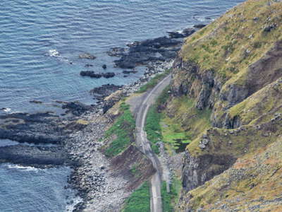 Bolungarvík | Abandoned road
 View from the summit area of Óshyrna. These sheer cliffs are the scene of frequent landslides such ...") Bolungarvík | Mountain cliff
Bolungarvík | Mountain cliff View from the summit area of Óshyrna. These sheer cliffs are the scene of frequent landslides such ...") Bolungarvík | Mountain cliff
Bolungarvík | Mountain cliff View from the summit area of Óshyrna. Its slopes are the scene of frequent landslides such as this ...") Bolungarvík | Ancient landslide
Bolungarvík | Ancient landslide This rock fracture runs along the small summit plateau of Óshyrna, SE of Bolungarvík. It has been ...") Óshyrna | Fracture
Óshyrna | Fracture This rock fracture runs along the small summit plateau of Óshyrna, SE of Bolungarvík. It has been ...") Óshyrna | Fracture
Óshyrna | Fracture NW slope of Drápuhlíðarfjall (527 m), an extinct volcano. The tongue-shaped feature in the centre...") Snæfellsnes | Drápuhlíðarfjall with landslide
Snæfellsnes | Drápuhlíðarfjall with landslide Panoramic view from Grettisbæli. This extremely mobile rock avalanche occurred in the morning of 7 ...") Hítardalur with Fagraskógarfjall-Hítardalur Landslide
Hítardalur with Fagraskógarfjall-Hítardalur Landslide View from Grettisbæli. This extremely mobile rock avalanche occurred in the morning of 7 July 2018....") Hítardalur with Fagraskógarfjall-Hítardalur Landslide
Hítardalur with Fagraskógarfjall-Hítardalur Landslide View from Grettisbæli. This extremely mobile rock avalanche occurred in the morning of 7 July 2018....") Fagraskógarfjall-Hítardalur Landslide
Fagraskógarfjall-Hítardalur Landslide This extremely mobile rock avalanche occurred in the morning of 7 July 2018. It travelled over a dis...") Fagraskógarfjall-Hítardalur Landslide | Panoramic view
Fagraskógarfjall-Hítardalur Landslide | Panoramic view This extremely mobile rock avalanche occurred in the morning of 7 July 2018. It travelled over a dis...") Fagraskógarfjall-Hítardalur Landslide | Panoramic view
Fagraskógarfjall-Hítardalur Landslide | Panoramic view View from the right side of the scarp in southeastern direction. This extremely mobile rock avalanch...") Fagraskógarfjall-Hítardalur Landslide | Impounded lake
Fagraskógarfjall-Hítardalur Landslide | Impounded lake This extremely mobile rock avalanche occurred in the morning of 7 July 2018. It travelled over a dis...") Fagraskógarfjall-Hítardalur Landslide | Seepage
Fagraskógarfjall-Hítardalur Landslide | Seepage This extremely mobile rock avalanche occurred in the morning of 7 July 2018. It travelled over a dis...") Fagraskógarfjall-Hítardalur Landslide | Panoramic view
Fagraskógarfjall-Hítardalur Landslide | Panoramic view View from the central part of the deposit in northwestern direction towards the scarp. This extremel...") Fagraskógarfjall-Hítardalur Landslide
Fagraskógarfjall-Hítardalur Landslide View from the deposit in northwestern direction towards the scarp. This extremely mobile rock avalan...") Fagraskógarfjall-Hítardalur Landslide
Fagraskógarfjall-Hítardalur Landslide View from the deposit in northwestern direction towards the scarp. This extremely mobile rock avalan...") Fagraskógarfjall-Hítardalur Landslide
Fagraskógarfjall-Hítardalur Landslide This extremely mobile rock avalanche occurred in the morning of 7 July 2018. It travelled over a dis...") Fagraskógarfjall-Hítardalur Landslide | Deposit
Fagraskógarfjall-Hítardalur Landslide | Deposit Release area of the extremely mobile rock avalanche which occurred in the morning of 7 July 2018. Th...") Fagraskógarfjall-Hítardalur Landslide | Scarp area
Fagraskógarfjall-Hítardalur Landslide | Scarp area This extremely mobile rock avalanche occurred in the morning of 7 July 2018. It travelled over a dis...") Fagraskógarfjall-Hítardalur Landslide
Fagraskógarfjall-Hítardalur Landslide This extremely mobile rock avalanche occurred in the morning of 7 July 2018. It travelled over a dis...") Fagraskógarfjall-Hítardalur Landslide
Fagraskógarfjall-Hítardalur Landslide View in eastern direction. Plymouth, the capital of Montserrat, was permanently evacuated in 1996 af...") Plymouth with Soufrière Hills Volcano
Plymouth with Soufrière Hills Volcano View in eastern direction. Plymouth, the capital of Montserrat, was permanently evacuated in 1996 af...") Plymouth with Soufrière Hills Volcano
Plymouth with Soufrière Hills Volcano View in western direction. Plymouth, the capital of Montserrat, was permanently evacuated in 1996 af...") Plymouth
Plymouth View in western direction. Plymouth, the capital of Montserrat, was permanently evacuated in 1996 af...") Plymouth | Town centre
Plymouth | Town centre Access to Plymouth is restricted, but a pier was constructed to export material extracted from pyroc...") Plymouth | Export of lahar deposits
Plymouth | Export of lahar deposits View in eastern direction. Plymouth, the capital of Montserrat, was permanently evacuated in 1996 af...") Plymouth and Soufrière Hills Volcano
Plymouth and Soufrière Hills Volcano View in eastern direction, Molyneaux Building in the foreground. Plymouth, the capital of Montserrat...") Plymouth and Soufrière Hills Volcano
Plymouth and Soufrière Hills Volcano Plymouth, the capital of Montserrat, was permanently evacuated in 1996 after the nearby Soufrière H...") Plymouth with Soufrière Hills Volcano
Plymouth with Soufrière Hills Volcano Plymouth, the capital of Montserrat, was permanently evacuated in 1996 after the nearby Soufrière H...") Plymouth | Town Hill with Soufrière Hills Volcano
Plymouth | Town Hill with Soufrière Hills Volcano View in eastern direction. The entire southern part of Montserrat had to be permanently evacuated af...") Soufrière Hills Volcano
Soufrière Hills Volcano View in eastern direction. The reactivation of the Soufrière Hills Volcano in 1995 has resulted in ...") Tar River mouth | New land
Tar River mouth | New land View in northern direction. The reactivation of the Soufrière Hills Volcano in 1995 has resulted in...") Tar River mouth | New land
Tar River mouth | New land Panoramic view from the trail to the Boiling Lake (ascent to Morne Nicholls) in northeastern directi...") Morne Trois Pitons NP
Morne Trois Pitons NP Panoramic view southwest to Morne Nicholls. The Valley of Desolation is a geothermally active area w...") Morne Trois Pitons NP | Valley of Desolation
Morne Trois Pitons NP | Valley of Desolation View from the final section of the trail to the Boiling Lake in southwestern direction. This area is...") Morne Trois Pitons NP with geothermal fields
Morne Trois Pitons NP with geothermal fields View from Morne Vert Pré. This cliff exposes mainly pyroclastic deposits at the western slope of Mo...") Le Prêcheur | Falaise Samperre
Le Prêcheur | Falaise Samperre View from Morne Vert Pré. This cliff exposes mainly pyroclastic deposits at the western slope of Mo...") Le Prêcheur | Falaise Samperre
Le Prêcheur | Falaise Samperre View from Morne Vert Pré. This cliff exposes mainly pyroclastic deposits at the western slope of Mo...") Le Prêcheur | Falaise Samperre
Le Prêcheur | Falaise Samperre This torrent drains the western slope of Montagne Pelée. It is susceptible to lahar flows involving...") Le Prêcheur | Rivière du Prêcheur
Le Prêcheur | Rivière du Prêcheur This torrent drains the western slope of Montagne Pelée. It is susceptible to lahar flows involving...") Le Prêcheur | Rivière du Prêcheur
Le Prêcheur | Rivière du Prêcheur This torrent drains the western slope of Montagne Pelée. It is susceptible to lahar flows involving...") Le Prêcheur | Rivière du Prêcheur at sunset
Le Prêcheur | Rivière du Prêcheur at sunset Sunset view from Pont du Prêcheur upstream. The Rivière du Prêcheur drains the western slope of M...") Le Prêcheur | Rivière du Prêcheur
Le Prêcheur | Rivière du Prêcheur Sunset view upstream, Pont du Prêcheur in the background. The Rivière du Prêcheur drains the west...") Le Prêcheur | Rivière du Prêcheur
Le Prêcheur | Rivière du Prêcheur The Rivière du Prêcheur drains the western slope of Montagne Pelée. It is susceptible to lahar fl...") Le Prêcheur | Mouth of Rivière du Prêcheur
Le Prêcheur | Mouth of Rivière du Prêcheur Erg Chebbi represents one of two large dune fields in the Moroccan part of the Sahara desert, with d...") Erg Chebbi | Sand flow
Erg Chebbi | Sand flow View from a levada nearby Cortado in SE direction to the village of Faial and the cliff of Penha de ...") Penha de Águia with rock fall
Penha de Águia with rock fall View from a levada nearby Cortado in SE direction to the village of Faial and the cliff of Penha de ...") Penha de Águia with rock fall
Penha de Águia with rock fall View from the road ER 213 in SE direction to the village of Faial and the cliff of Penha de Águia, ...") Faial with Penha de Águia
Faial with Penha de Águia Panoramic view from the road ER 213 in SE direction to the village of Faial and the cliff of Penha d...") Faial with Penha de Águia
Faial with Penha de Águia View from the road ER 213 in SE direction to the deposit of a rock fall event from Penha de Águia, ...") Penha de Águia | Rock fall deposit
Penha de Águia | Rock fall deposit The road connecting the Boca da Encumeada with the highland Paul da Serra crosses the steep E face o...") Paul da Serra | Warning sign
Paul da Serra | Warning sign The coal from this mine - in operation since 1978 - is used to fuel the thermal power plants in Ulaa...") Baganuur | Brown coal mine
Baganuur | Brown coal mine The coal from this mine - in operation since 1978 - is used for the thermal power plants in Ulaan Ba...") Baganuur | Brown coal mine with coal seam and landslide
Baganuur | Brown coal mine with coal seam and landslide The coal from this mine - in operation since 1978 - is used for the thermal power plants in Ulaan Ba...") Baganuur | Brown coal mine with landslide
Baganuur | Brown coal mine with landslide The coal from this mine - in operation since 1978 - is used for the thermal power plants in Ulaan Ba...") Baganuur | Brown coal mine
Baganuur | Brown coal mine Svartisen represents the second largest plateau glacier in Norway, whereas Austerdalsisen forms one ...") Svartisen | Austerdalsisen
Svartisen | Austerdalsisen View from the road section between Ghasa and Kalopani") Kali Gandaki Valley | Landslides
Kali Gandaki Valley | Landslides Okharpauwa, northwest of Kathmandu. This debris flow temporarily blocked the course of the stream, w...") Lesser Himalaya | Debris flow deposit
Lesser Himalaya | Debris flow deposit This village is located on a huge ancient rock slide at approx. 3800 m asl. Kongde Ri (6187 m) appea...") Khumjung and Kongde Ri
Khumjung and Kongde Ri This village is located on an ancient rock slide at approx. 3800 m asl. As shown in the right portio...") Kunde with debris flow
Kunde with debris flow The villages of Kunde (left side) and Khumjung (right centre) have been built on a huge ancient rock...") Kunde and Khumjung with rock slide deposit
Kunde and Khumjung with rock slide deposit This photograph shows part of the deposit of a huge ancient rock slide. Mt. Everest (8848 m), Lhotse...") Kunde and Khumjung | Rock slide deposit
Kunde and Khumjung | Rock slide deposit Uluru-Kata Tjuta National Park, view from Kuniya Walk to the southernmost portion of Australia's maj...") Uluru / Ayers Rock | Rock fall
Uluru / Ayers Rock | Rock fall Location: near Porters Pass. The rock avalanche of several millions of cubic metres was probably tri...") Acheron Rock Avalanche | Release area
Acheron Rock Avalanche | Release area Location: near Porters Pass. The rock avalanche of several millions of cubic metres, which travelled...") Acheron Rock Avalanche | Panorama
Acheron Rock Avalanche | Panorama Location: near Porters Pass. The rock avalanche of several millions of cubic metres, which travelled...") Acheron Rock Avalanche | Panorama
Acheron Rock Avalanche | Panorama State Highway 6 crosses the landslide body.") Lake Wanaka with landslide
Lake Wanaka with landslide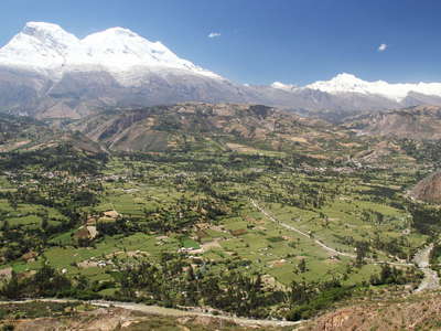 Cordillera Blanca with debris cone of Ranrahirca
 Sunset view from Matacoto to the lower N summit (6654 m) of the highest tropical mountain worldwide....") Cordillera Blanca | Nevado Huascarán Norte
Cordillera Blanca | Nevado Huascarán Norte View from the slopes of the Cordillera Negra to the lower N summit (6654 m) of the highest tropical ...") Cordillera Blanca | Nevado Huascarán Norte
Cordillera Blanca | Nevado Huascarán Norte View from the slopes of the Cordillera Negra to the highest tropical mountain worldwide (6768 m). Th...") Callejón de Huaylas with Nevado Huascarán
Callejón de Huaylas with Nevado Huascarán View from the slopes of the Cordillera Negra to the highest tropical mountain worldwide (6768 m). Th...") Callejón de Huaylas with Nevado Huascarán
Callejón de Huaylas with Nevado Huascarán Nueva Yungay (left portion of the image) was founded after the original town had been destroyed by a...") Callejón de Huaylas | Nueva Yungay and Campo Santo
Callejón de Huaylas | Nueva Yungay and Campo Santo Campo Santo represents the site of the original town of Yungay, which was destroyed on 31 May 1970 w...") Yungay | Campo Santo
Yungay | Campo Santo Campo Santo represents the site of the original town of Yungay, which was destroyed on 31 May 1970 w...") Yungay | Campo Santo with cemetery hill
Yungay | Campo Santo with cemetery hill Campo Santo represents the site of the original town of Yungay, which was destroyed on 31 May 1970 w...") Yungay | Campo Santo with destroyed bus
Yungay | Campo Santo with destroyed bus Campo Santo represents the site of the original town of Yungay, which was destroyed on 31 May 1970 w...") Yungay | Campo Santo with church ruins
Yungay | Campo Santo with church ruins Campo Santo represents the site of the original town of Yungay, which was destroyed on 31 May 1970 w...") Yungay | Campo Santo
Yungay | Campo Santo Campo Santo represents the site of the original town of Yungay, which was destroyed on 31 May 1970 w...") Yungay | Campo Santo
Yungay | Campo Santo View from the cemetery hill in NE direction. Campo Santo represents the site of the original town of...") Yungay | Campo Santo with Nevado Huascarán
Yungay | Campo Santo with Nevado Huascarán The Rampac Grande Landslide (right portion of the image) is one of many mass movements observed in t...") Carhuaz | Rampac Grande Landslide
Carhuaz | Rampac Grande Landslide These boulders go back to a glacial lake outburst flood (GLOF) in 2010, when an ice avalanche from t...") Quebrada Hualcán | GLOF deposit
Quebrada Hualcán | GLOF deposit The debris cone in the left part of this photograph dates back to 1952. It is the result of an outbu...") Quebrada Ishinca | Panoramic view
Quebrada Ishinca | Panoramic view The debris cone dominating this photograph dates back to 1952. It is the result of a glacial lake ou...") Quebrada Ishinca | Debris cone of Laguna Milluacocha GLOF
Quebrada Ishinca | Debris cone of Laguna Milluacocha GLOF Ice avalanches are a common phenomenon in those places where glaciers retreat over steep rock walls....") Quebrada Ishinca | Ice avalanche
Quebrada Ishinca | Ice avalanche Until 13 December 1941, Laguna Palcacocha was impounded behind the horseshoe-shaped moraine ridge se...") Laguna Palcacocha | Panoramic view
Laguna Palcacocha | Panoramic view Until 13 December 1941, Laguna Palcacocha was impounded behind the horseshoe-shaped moraine ridge se...") Laguna Palcacocha
Laguna Palcacocha Ice avalanches are a common phenomenon in those places where glaciers retreat over steep rock walls....") Cordillera Blanca | Ice avalanche at Nevado Palcaraju
Cordillera Blanca | Ice avalanche at Nevado Palcaraju Whereas Laguna Palcacocha has grown substantially during the past decades, there is only some minor ...") Laguna Palcacocha with regenerating glacier and landslide scar
Laguna Palcacocha with regenerating glacier and landslide scar View from Mirador de Antahuilque in NW (downstream) direction. The Colca Valley has been inhabited s...") Valle del Colca with Madrigal
Valle del Colca with Madrigal View from Mirador de Wayrac Punku in E (upstream) direction. The Colca Valley has been inhabited sin...") Valle del Colca | Panoramic view with Madrigal
Valle del Colca | Panoramic view with Madrigal View from Mirador de Wayrac Punku in NE direction. This section of the Colca Valley has been influen...") Valle del Colca | Panoramic view with Madrigal
Valle del Colca | Panoramic view with Madrigal View from Mirador de Wayrac Punku in NE direction. This section of the Colca Valley has been influen...") Valle del Colca with landslide of Madrigal
Valle del Colca with landslide of Madrigal View from Mirador de Wayrac Punku in NE direction. This section of the Colca Valley has been influen...") Valle del Colca | Landslide of Madrigal in 2018
Valle del Colca | Landslide of Madrigal in 2018 View from Mirador de Wayrac Punku in NE direction. This section of the Colca Valley has been influen...") Valle del Colca | Landslide of Madrigal in 2022
Valle del Colca | Landslide of Madrigal in 2022 View from Mirador de Wayrac Punku in E (upstream) direction. The Colca Valley has been inhabited sin...") Valle del Colca with terraced farmland
Valle del Colca with terraced farmland View in NW (downstream) direction. The Colca Valley has been inhabited since pre-Incan times, so tha...") Valle del Colca
Valle del Colca View from Mirador de Antahuilque in NE direction. The Colca Valley has been inhabited since pre-Inca...") Valle del Colca | Panoramic view with Madrigal and Lari
Valle del Colca | Panoramic view with Madrigal and Lari View from Mirador de Antahuilque in NE (upstream) direction. The Colca Valley has been inhabited sin...") Valle del Colca | Panoramic view with Lari
Valle del Colca | Panoramic view with Lari View from Mirador de Antahuilque in E (upstream) direction. The Colca Valley has been inhabited sinc...") Valle del Colca | Panoramic view with Lari and Maca
Valle del Colca | Panoramic view with Lari and Maca View in N direction. The Colca Valley has been inhabited since pre-Incan times, so that ancient terr...") Valle del Colca | Panoramic view with terraced farmland
Valle del Colca | Panoramic view with terraced farmland View in E (upstream) direction. This section of the Colca Valley has been influenced by earthquakes,...") Valle del Colca | Landslide of Maca
Valle del Colca | Landslide of Maca Panoramic afternoon view of Laguna Humantay and the glacierized Humantay massif with Tukarway (left ...") Cordillera Vilcabamba | Laguna Humantay
Cordillera Vilcabamba | Laguna Humantay Panoramic view of the S face of Nevado Salkantay (6271 m), the highest peak of the Cordillera Vilcab...") Cordillera Vilcabamba | Nevado Salkantay and Laguna Salkantaycocha
Cordillera Vilcabamba | Nevado Salkantay and Laguna Salkantaycocha S face of Nevado Salkantay (6271 m). The landslide scar in the upper centre of the scene goes back t...") Cordillera Vilcabamba | Nevado Salkantay
Cordillera Vilcabamba | Nevado Salkantay S face of Nevado Salkantay (6271 m). The prominent landslide scar in the centre of the scene goes ba...") Nevado Salkantay with rock slide scar
Nevado Salkantay with rock slide scar S face of Nevado Salkantay (6271 m). The prominent landslide scar in the centre of the scene goes ba...") Nevado Salkantay with rock slide scar
Nevado Salkantay with rock slide scar View from Abra Salkantay (4630 m) in SE direction across the Salkantay Glacier bounded by pronounced...") Cordillera Vilcabamba | Rock avalanche deposit at Abra Salkantay
Cordillera Vilcabamba | Rock avalanche deposit at Abra Salkantay Basin of the moraine-dammed Laguna Salkantaycocha. On 23 February 2020, a huge chunk of rock and ice...") Cordillera Vilcabamba | Laguna Salkantaycocha
Cordillera Vilcabamba | Laguna Salkantaycocha Panoramic view of the uppermost part of Quebrada Humantay, with Nevado Salkantay (6271 m) in the rig...") Quebrada Humantay | GLOF impact area of 2020
Quebrada Humantay | GLOF impact area of 2020 View of the distal slope of the moraine dam of Laguna Salkantaycocha with Nevado Salkantay (6271 m) ...") Nevado Salkantay and eroded terminal moraine
Nevado Salkantay and eroded terminal moraine View of the distal slope of the moraine dam of Laguna Salkantaycocha with Nevado Salkantay (6271 m) ...") Nevado Salkantay and eroded terminal moraine
Nevado Salkantay and eroded terminal moraine View of the distal slope of the moraine dam of Laguna Salkantaycocha with Nevado Salkantay (6271 m) ...") Nevado Salkantay and eroded terminal moraine
Nevado Salkantay and eroded terminal moraine View upstream. In this place, the glacial lake outburst flood (GLOF) process chain of 2020 has erode...") Quebrada Humantay with traces of the 2020 GLOF
Quebrada Humantay with traces of the 2020 GLOF View upstream. The glacial lake outburst flood (GLOF) process chain of 2020 has eroded the banks of ...") Quebrada Humantay with traces of the 2020 GLOF
Quebrada Humantay with traces of the 2020 GLOF View upstream, Salkantay Trek with hikers on the right side. The glacial lake outburst flood (GLOF) ...") Quebrada Humantay with landslide
Quebrada Humantay with landslide The confluence of Quebrada Humantay (view upstream) and the valley of the Río Santa Teresa (foregro...") Santa Teresa Valley with Quebrada Humantay and Chaullay
Santa Teresa Valley with Quebrada Humantay and Chaullay View up the Río Santa Teresa in the vicinity of Winaypocco in S direction. Satellite imagery of 201...") Cordillera Vilcabamba | Río Santa Teresa with landslide
Cordillera Vilcabamba | Río Santa Teresa with landslide View up the Río Santa Teresa in the vicinity of Lloska Mayu in SE direction. The landslide (outer b...") Cordillera Vilcabamba | Río Santa Teresa with landslide
Cordillera Vilcabamba | Río Santa Teresa with landslide Panoramic view up the Río Santa Teresa in the vicinity of Lloska Mayu in S direction. The landslide...") Cordillera Vilcabamba | Río Santa Teresa
Cordillera Vilcabamba | Río Santa Teresa View down the Río Santa Teresa in the vicinity of Lloska Mayu in N direction. The landslide in the ...") Cordillera Vilcabamba | Río Santa Teresa
Cordillera Vilcabamba | Río Santa Teresa View up the Río Santa Teresa and over Sahuayaco in SW direction. This village was badly affected by...") Santa Teresa Valley | Sahuayaco
Santa Teresa Valley | Sahuayaco The coastal road connecting Saint-Paul and Saint-Gilles les-Bains runs below a high cliff and theref...") Cap de la Houssaye | Coastal highway
Cap de la Houssaye | Coastal highway View from the summit area of Le Grand Bénare into the Cirque de Mafate with the Rivière des Galets...") Cirque de Mafate | Rivière des Galets
Cirque de Mafate | Rivière des Galets This monastery of Eastern Orthodox nuns has been severely affected by a landslide occurring beneath ...") Mănăstirea Răteşti | Landslide damage
Mănăstirea Răteşti | Landslide damage This monastery of Eastern Orthodox nuns has been severely affected by a landslide occurring beneath ...") Mănăstirea Răteşti | Landslide damage
Mănăstirea Răteşti | Landslide damage This monastery of Eastern Orthodox nuns has been severely affected by a landslide occurring beneath ...") Mănăstirea Răteşti | Landslide damage
Mănăstirea Răteşti | Landslide damage This monastery of Eastern Orthodox nuns has been severely affected by a landslide occurring beneath ...") Mănăstirea Răteşti | Landslide damage
Mănăstirea Răteşti | Landslide damage This monastery of Eastern Orthodox nuns has been severely affected by a landslide occurring beneath ...") Mănăstirea Răteşti | Landslide damage
Mănăstirea Răteşti | Landslide damage This monastery of Eastern Orthodox nuns has been severely affected by a landslide occurring beneath ...") Mănăstirea Răteşti | Landslide damage
Mănăstirea Răteşti | Landslide damage This monastery of Eastern Orthodox nuns has been severely affected by a landslide occurring beneath ...") Mănăstirea Răteşti | Landslide damage
Mănăstirea Răteşti | Landslide damage This electricity pole stands on a landslide area.") Pârjolești | Leaning electricity pole
Pârjolești | Leaning electricity pole The Mușcel Catchment is characterized by flysch and molasse deposits. Due to their high content of ...") Mușcel | Hillscape with landslides
Mușcel | Hillscape with landslides The Mușcel Catchment is characterized by flysch and molasse deposits. Due to their high content of ...") Mușcel | Landslides
Mușcel | Landslides The Mușcel Catchment is characterized by flysch and molasse deposits. Due to their high content of ...") Mușcel | Landslides
Mușcel | Landslides The Mușcel Catchment is characterized by flysch and molasse deposits. Due to their high content of ...") Mușcel | Hillscape with landslides
Mușcel | Hillscape with landslides The Mușcel Catchment is not ony characterized by herds of sheep, but also by flysch and molasse dep...") Mușcel | Herd of sheep
Mușcel | Herd of sheep The Mușcel Catchment is characterized by flysch and molasse deposits. Due to their high content of ...") Mușcel | Hillscape with landslides
Mușcel | Hillscape with landslides The Mușcel Catchment is characterized by flysch and molasse deposits. Due to their high content of ...") Mușcel | Earth flow
Mușcel | Earth flow Mud volcanoes are associated to exhalations of gas - mainly methane - mobilizing water and fine sedi...") Pâclele Mari | Mud volcano
Pâclele Mari | Mud volcano Mud volcanoes are associated to exhalations of gas - mainly methane - mobilizing water and fine sedi...") Pâclele Mici | Mud volcano landscape
Pâclele Mici | Mud volcano landscape Mud volcanoes are associated to exhalations of gas - mainly methane - mobilizing water and fine sedi...") Pâclele Mici | Mud volcano landscape
Pâclele Mici | Mud volcano landscape Mud volcanoes are associated to exhalations of gas - mainly methane - mobilizing water and fine sedi...") Pâclele Mici | Mud volcano
Pâclele Mici | Mud volcano Mud volcanoes are associated to exhalations of gas - mainly methane - mobilizing water and fine sedi...") Pâclele Mici | Former flow from mud volcano
Pâclele Mici | Former flow from mud volcano Mud volcanoes are associated to exhalations of gas - mainly methane - mobilizing water and fine sedi...") Pâclele Mici | Mud volcano with outflow
Pâclele Mici | Mud volcano with outflow Mud volcanoes are associated to exhalations of gas - mainly methane - mobilizing water and fine sedi...") Pâclele Mari | Mud volcano with outflow
Pâclele Mari | Mud volcano with outflow Mud volcanoes are associated to exhalations of gas - mainly methane - mobilizing water and fine sedi...") Pâclele Mari | Mud volcano with outflow
Pâclele Mari | Mud volcano with outflow Headscarp of the Chirlești Earth Flow with layers of clay-rich sedimentary rocks. The valley of the...") Chirlești | Source area of earth flow
Chirlești | Source area of earth flow Secondary scarp of the Chirlești Earth Flow with layers of clay-rich sedimentary rocks") Chirlești | Source area of earth flow
Chirlești | Source area of earth flow Secondary scarp of the Chirlești Earth Flow with layers of clay-rich sedimentary rocks") Chirlești | Source area of earth flow
Chirlești | Source area of earth flow